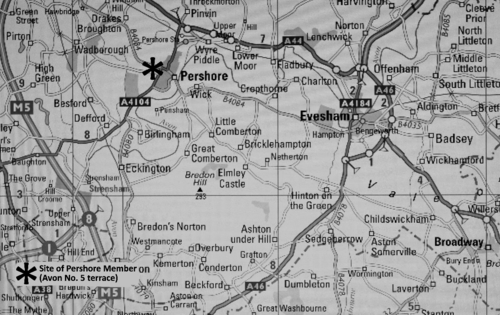
An exposure in the Pershore Member of the Avon Valley Formation at February Piece, Allesborough Hill, Pershore, Worcestershire
Paul F. Whitehead
Moor Leys, Little Comberton, Pershore, Worcestershire WR10 3EH email: paul@thewhiteheads.eu
Introduction
Changes in the fluvial regime of the River Avon during the past 300,000 years or so have resulted in the deposition of Pleistocene sands and gravels traceable under a series of terraces traditionally numbered from one to five in ascending order above alluvium (Tomlinson, 1925). These comprise what is now the Avon Valley Formation. De Ruffignac et al. (1995) established the existence of a further aggradation, the Strensham Member, which has not yet been accommodated within a numbered framework (Table 1). It should be noted that the depositional history below a single ‘terrace’ surface may transcend a range of climates (Whitehead, 1992), a matter now rather more subtly demonstrated within the Pershore Member (Table 1).
Evidence for climate and biota of the Pershore Member were unknown until 1975. In that year contemporaneous plants, molluscs and vertebrates were obtained from sections cut during a road-widening scheme (03) on Allesborough Hill, Pershore (Whitehead, 1989a).
During March 2014 building work commenced at a site at Allesborough Hill, Pershore, known as February Piece (SO9346. 01 & 02), a name deriving from the ameliorating effects of underlying sands and gravels on traditional arable cropping practice. Construction work required the installation of a pipe trench almost four metres deep (02); this sectioned the entire thickness of the Quaternary sediments the visible evidence for which forms the basis of this paper.
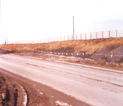
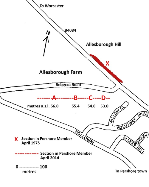 |
| 02. Avon Valley Formation. Location of pipe-trench section A – D through Pershore Member, February Piece, Pershore, Worcestershire, April 2014 in relation to the April 1975 exposure (03). Ordnance Survey grid references for A - SO93744620; B - SO93794621; C - SO93854622; D - SO93894623. |
These relatively high level sediments, some 37 m above modern alluvium, provide some degree of correlation with the release of water from pro-glacial Lake Harrison (Bishop, 1958) which established the modern Worcestershire River Avon. This reversed the directional flow of its fluvial predecessor (Shotton, 1968) leading ultimately to the creation of the Severn-Avon confluence at Tewkesbury. Sediments above the modern river valley on higher ground to the north are glacigenic or glaciofluvial in origin.
Terrace no. | Member/bed no & name | Above alluvium | MIS | Years BP | Time period |
Avon No 1 | *Bretford Member | 1m (Lower Moor) | 2 | 12500 | Devensian |
Avon No 2 | *Wasperton Member | 3m | 2 | 29000 | Devensian |
Avon No 3 | ***New Inn Member | 8m | 5e | 120000 | Ipswichian |
Avon No 3 | ***Eckington Bed | 8m | 5e | 120000 | Ipswichian |
Avon No 4 | Twyning Member | 18m *Lower Bed | 6 | 150000 | ‘Wolstonian’ |
Avon No 4 | Twyning Member | 21m ***Upper Bed | 7 | 180000 | ‘Wolstonian’ |
Avon No 4 | ***Cropthorne Member | 19m | 7 | 200000 | ‘Wolstonian’ |
-------------- | **Strensham Member | 29m | 7 | 220000 | ‘Wolstonian’ |
Avon No 5 | *Pershore Member | 37m | 8 | 270000 | ‘Wolstonian’ |
Avon No 5 | **Allesborough Bed | 33m | 8 | 280000 | ‘Wolstonian’ |
Table 1. The Avon Valley Formation as at 2014. Chronological sequence of aggradations by increasing age downwards, geological name, surface height above alluvium, marine isotope stage (MIS) and guideline dates (“Years BP” approximation of years before present in part from Lisiecki & Raymo, 2005). The traditional application of the ‘Wolstonian’ stage name requires clarification to accept the range of climatic variation indicated here. Simplified climate and biota: *full glacial **cool temperate ***warm temperate.
Sedimentology
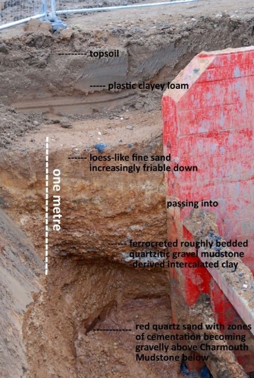
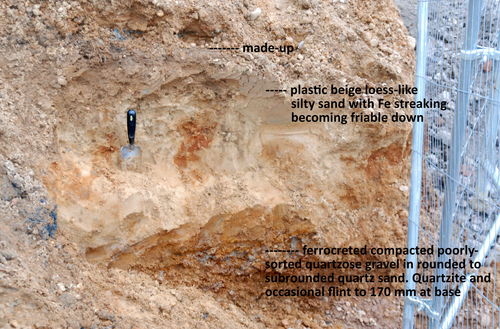
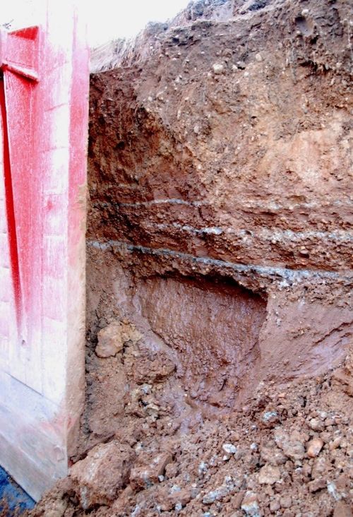
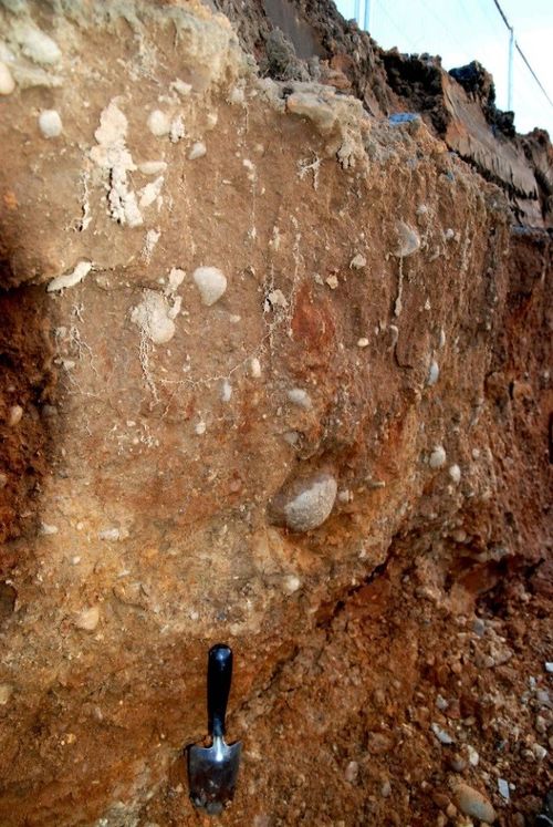
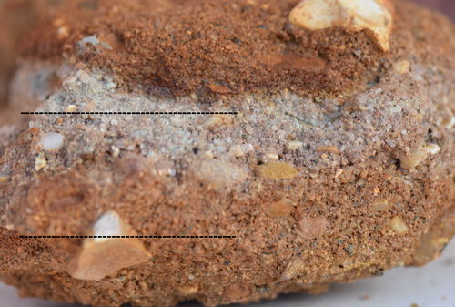
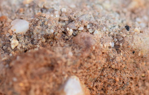
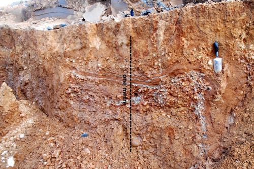
The approximate length of the visible pipe-trench section during April 2014 is shown in 02 with stations A-D indicating where observations were more focussed. The sediments varied in their fine details along the length of the cutting but 04 typifies them and illustrates the use of large retaining frames required to overcome sediment instability. The basal unit consists of a thick layer of unbedded red quartzose sand resting on Jurassic bedrock, unstable in section due to active zones of water transmission (04, 06). These sands, not everywhere equally evident but in places somewhat gravelly basally, are believed to be the fill of channels with changing or variable flow rates. The sand presumably results from seasonal weathering effects in an open exposed landscape. The sand is composed of subrounded to subangular grains with an average diameter (visual scan of thousands) of 0.3 mm; a quartz grain measuring 3 mm diameter was noted together with larger rounded quartzite fragments. The sand grain edges are all more effaced than those of the upper loessic sands (see below). The binding matrix of the sand is ‘dust’ or silt with particle sizes submicroscopic but at least as small as 0.002 mm diameter; this is presumably loessic dust introduced from an open exposed treeless landscape.
Trias-derived coarser gravel dominated by quartzite and flint in a quartzose sand matrix with little local Jurassic content, in places brecciated by ferrocretion (04, 10a & 10b), overlies the red sand unit. These gravels are overlain by finer friable sandy sediments which have the characteristics of loess and attain a thickness of 40 cms in places (04 & 05). These unbedded sediments are composed of interlocking subangular to subrounded sand grains bound by traces of calcareous ‘dust’ or silt. The sand grains vary from 0.09 mm to 0.7 mm diameter, an average diameter being close to 0.3 mm. These may have originated from exposed high ground or plateaux above the catchment and may be of glacigenic origin. The modern land surface is underlain by loams with a significant Jurassic clay content introduced from upslope over a probably extended time period.
Climate of deposition
The upper sands and gravels have been subjected to a range of cold climate processes for which significant visible evidence was found. These include cryoturbation (08) and ice-wedge pseudomorphs or casts, ground contraction fissures subsequently refilled with sediment (07).
 |
| 07. Avon Valley Formation Pershore Member, February Piece, Pershore, Worcestershire, 8 April 2014. Cryoturbation of ‘loessic sand’ and underlying gravels with intraformational ice wedge cast almost one metre deep. Northern face of pipe trench close to A in 02 SO93744620. Context is visible also at west end of 08. |
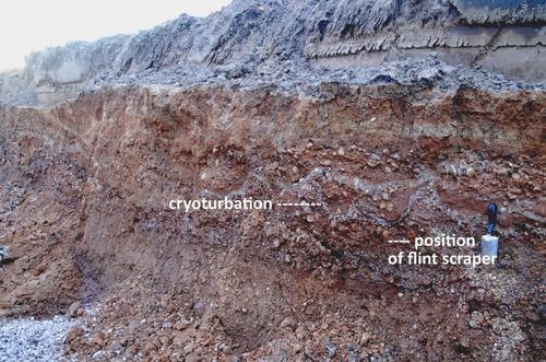 |
| 08. Avon Valley Formation Pershore Member, February Piece, Pershore, Worcestershire, 8 April 2014. Location of flint scraper (10) in ferrocreted flint, quartz, and quartzite gravel with abundant frequently subangular to angular quartz grains. Northern face of pipe trench at A in 02 SO93744620. Trowel is 28 cms long. |
There is also evidence for the infilling from upslope of surface depressions of possible cryogenic origin with diamicton in which larger clasts were haphazardly suspended in a viscous mobile matrix of finer sediment (09); this process is believed to be broadly contemporaneous with member development but this is not proven.
These features demonstrate that towards the end of aggradation the climate was of full glacial severity with the development of permafrost. This climatic deterioration is held to occupy the maximum cold of Marine Isotope Stage 8 (MIS 8) occupying ‘Wolstonian’ time. The Allesborough Bed (Whitehead, 1989a; Maddy, 1999) is here regarded as marginally older than the sediments of the Pershore Member and contains cool temperate biotic elements.
Geochronological implications for the Worcestershire River Avon valley
If it is accepted that these periglacial conditions mark MIS 8 and that the full glacial sediments of the basal Twyning Bed (Avon No. 4 terrace of Whitehead, 1989a; 1992 actually in Watsonian East Gloucestershire) are pre-Devensian a clear scenario presents itself. The first major episode in the cutting of the modern River Avon consequent to the drainage of Lake Harrison during the ‘Wolstonian’ deepened its valley by 20 m before the Twyning basal bed aggraded in MIS 6 time. The Strensham and Cropthorne members represent halt stages in this process during MIS 7 when sea level rose again; the observations on MIS 7 made by Lang & Wolff (2011) are highly pertinent when attempting to disentangle the finer nuances of River Avon ‘terrace’ climate and biota.
On this basis three ice ages passed whilst the modern River Avon incised to its present level thus according with Bowen (1999) and Lowe & Walker (2014). When Keen (1999) implied a MIS 9 age (followed by van Asperen, 2009) for the Pershore Member it was on the basis of working back from the known ages of the younger terraces; he appears to have overlooked the full glacial biota beneath Avon No. 4 terrace surface at Twyning (Whitehead, 1989a; 1992) with the implication now that the English Midland ‘Wolstonian’ may not require to be moved back in time and that the sequential position of Avon No. 5 terrace is closer to the ‘old’ one (Shotton, 1973). Sutcliffe (1995) did acknowledge Avon No. 4 terrace at Twyning and he too discussed the problematical use of ‘Wolstonian’ as a stage name, a discussion that is still ongoing (Bridle, 2012). It seems to me improbable that the Allesborough Bed at Pershore sensu Maddy (1999), possibly reflecting the demise of the large mammal fauna prior to the onset of full glacial conditions, is significantly different in age to the Pershore Member at Pershore.
In referring to Avon No. 5 terrace Keen (1999) employed the term ‘interglacial’ on the basis of ‘temperate’ biotic elements but these are few and, especially in the light of this new evidence reference to an interglacial is not advisable. The descent to full-glacial could have been rapid. The absence of a full glacial ‘mammoth-steppe megafauna’ in the Pershore Member might, if it is real, be explained by the absence of rich productive floodplain grassland. This is known to have reached its greatest development on two subsequent occasions but only after enough time had been allowed for the river to become well incised into bedrock and create the fluvial regimes that favoured this habitat and its distinctive biota.
Archaeology
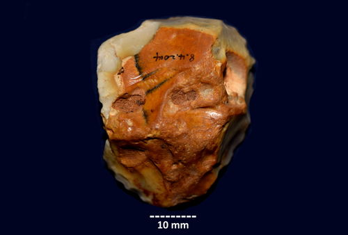
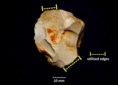
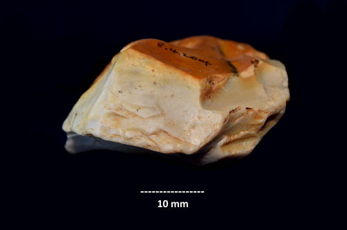
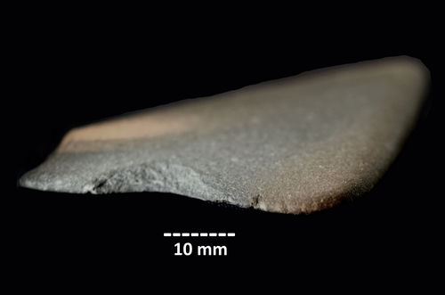
Two lithic artefacts recovered from the pipe trench are the only evidence of human culture from the Pershore Member up to now. They are a discoidal scraper (11a, 11b & 11c) of early Middle Palaeolithic affinity worked on coarse far-travelled cherty flint with centripetal removals defining one flat surface (11b). The exact in situ position of the scraper in the quartzose sands and gravels is depicted in 08.
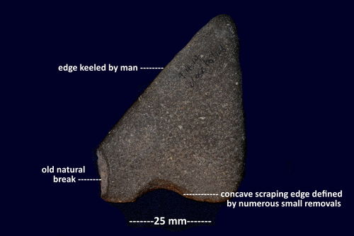
The second artefact is a concave scraper worked on Jurassic fine-grained micaceous siltstone (12a, 12b) found ex situ close to the contact of the gravel and bedrock. The siltstone is uniformly laminar, some four millimetres thick with its long-edge facetted by man; this allows it to rest easily between the index finger and a platform created by another finger of the same hand. Jurassic micaceous siltstones and ironstone were observed near or close to the contact of the sands and gravels with the underlying Charmouth Mudstone. Neanderthal man evidently found that brittle Jurassic siltstone constituted an acceptable resource which is suggestive of local human presence.
Biota
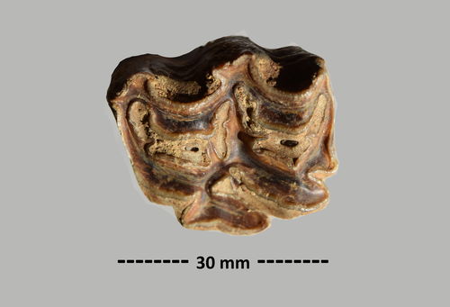
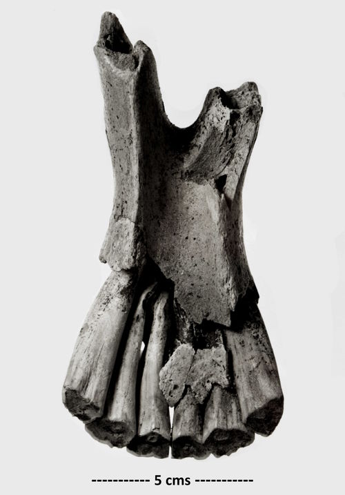
No organic lenses or contemporary invertebrates could be detected anywhere in the pipe trench sediments. A single upper molar tooth of a medium sized wild horse Equus ferus Boddaert, 1785 (13) was found close to the contact of the Pleistocene and Jurassic sediments. This is the earliest name available for the Middle and Late Pleistocene wild horse following Kaagan (2000), Whitehead (2006) and van Asperen (2009). The specimen is from a healthy young adult animal and is in fresh unabraded condition. A feature of the large mammal bones from this site is their low level of secondary calcification and absence of post-mortem weathering. In the 1975 exposure (03) remains of Wild Horse, together with Red Deer Cervus elaphus L., also occurred including fresh unabraded specimens from populations living at or near their point of burial shortly after death (14). These were concentrated at the base of a channel cut into the Charmouth Mudstone (03) overlain by reddish sands and gravels very like those observed in the 2014 pipe trench.
The work of both Kaagan (2000) and van Asperen (2009) have brought much needed uniformity to wild horse taxonomy and evolution, the absence of which hindered earlier publications (Whitehead, 1977, 1989b). The horse from the Pershore Member at Pershore, whilst robust, is less stocky than the more recent MIS 6 and MIS 2 full glacial horses from the River Avon valley; perhaps it was less well-adapted to the more extreme conditions of the Middle Pleistocene full glacial environment.
Footnote
The author has limited sealed sediment samples from a number of the units underlying February Piece and would be pleased to make some available to support U.K. scientific research by arrangement. The two lithic artefacts from this site will be donated to Evesham Almonry Museum for permanent accession.
Acknowledgements
The author wishes to thank Redrow plc and their subcontractors for facilities readily provided to undertake this study in the absence of which the evidence would have been lost forever. Dr Eline van Asperen patiently discussed some finer details of Pleistocene equid skeletal morphology.
References
Bishop, W.W., 1958. The Pleistocene geology and geomorphology of three gaps in the midland Jurassic escarpment. Philosophical Transactions of the Royal Society of London B 241:255-306.
Bowen, D.Q., 1999. On the correlation and classification of Quaternary deposits and land-sea correlation pp. 1-9 in: Bowen, D.Q. (ed.), A revised correlation of Quaternary deposits in the British Isles. Geological Society. Bath.
Bridle, A., 2012. The mid-to-late Pleistocene palaeoenvironments of the Gordano Valley, North Somerset. PhD, University of the West of England. http://eprints.uwe.ac.uk/18104/.
De Ruffignac, C., Bowen, D.Q., Coope, G.R., Keen, D.H., Lister, A.M., Maddy, D., Robinson, J.E., Sykes, G.A. & Walker, M.J.C., 1995. Late Middle Pleistocene interglacial deposits at Upper Strensham, Worcestershire, England. Journal of Quaternary Science 10:15-31.
Kaagan, L.M., 2000. The horse in late Pleistocene and Holocene Britain. Ph.D. thesis, Department of Biology, University College, London, February 2000.
Keen, D.H., 1999. The chronology of Middle Pleistocene (‘Wolstonian’) events in the English Midlands pp. 159-168 in: Andrews, P. & Banham, P. (eds), Late Cenozoic environments and hominid evolution: a tribute to Bill Bishop. Geological Society of London.
Lang, N. & Wolff, E.W., 2011. Interglacial and glacial variability from the last 800 ka in marine, ice and terrestrial archives. Climate of the Past 7:361–380.
Lisiecki, L.E. & Raymo, M.E., 2005. A Pliocene-Pleistocene stack of 57 globally distributed benthic δ18O records. doi: 10.1029/2004PA001071.
Lowe, J.J. & Walker, M.J.C., 2014. Reconstructing Quaternary environments. Routledge, Abingdon & New York.
Maddy, D., 1999. English Midlands pp. 28-44 in: Bowen, D.Q. (ed.), A revised correlation of Quaternary deposits in the British Isles. Geological Society. Bath.
Shotton, F.W., 1968. The Pleistocene succession around Brandon, Warwickshire. Philosophical Transactions of the Royal Society of London B 254:387-400.
Shotton, F.W., 1973. English Midlands pp. 18-22 in: Mitchell, G.F., Penny, L.F., Shotton, F.W. & West, R.G., A correlation of Quaternary deposits in the British Isles. Geological Society of London Special Report 4.
Sutcliffe, A.J., 1995. Insularity of the British Isles 250000-30000 years ago: the mammalian, including human, evidence pp. 127-140 in: Preece, R.C. (ed.) Island Britain: a Quaternary perspective. Geological Society Special Publication 96.
Tomlinson, M E. 1925. The river terraces of the lower valley of the Warwickshire Avon. Quarterly Journal of the Geological Society of London 81:137-169.
Van Asperen, E., 2009. Caballoid horses and late Middle Pleistocene biostratigraphy of the British Isles. Quaternaire 20:437-448.
Whitehead, P.F., 1977. Vertebrate fauna from the Carrant Main Terrace pp. 45-47 in: Shotton F.W. (ed.), The English Midlands: Guidebook for excursion A2 X INQUA Congress.
Whitehead, P.F., 1979. A tooth of Equus cf. spelaeus gallicus Prat (1968) from the Cotswolds. Quaternary Newsletter 29:18-20.
Whitehead, P.F., 1989a. Development and sequence of deposition of the Avon Valley river terraces, pp. 37-41 in: Keen D.H. (ed.), The Pleistocene of the West Midlands: Field Guide. Quaternary Research Association. Cambridge.
Whitehead, P.F., 1989b. A wild horse bone from Bredon Hill, Worcestershire. Quaternary Newsletter 59:24.
Whitehead, P.F., 1992. Terraces of the River Avon at Twyning, Gloucestershire; their stratigraphy climate and biota (with Appendices 1 & 2). Quaternary Newsletter 67:3-29.
Whitehead, P.F., 2006. Evidence of wild horse Equus ferus at South Littleton. Worcestershire Record 20:42.
Images
01. Avon Valley Formation. Site of Pershore Member, Allesborough Hill, Pershore, Worcestershire.
02. Avon Valley Formation. Location of pipe-trench section A – D through Pershore Member, February Piece, Pershore, Worcestershire, April 2014 in relation to the April 1975 exposure (03). Ordnance Survey grid references for A - SO93744620; B - SO93794621; C - SO93854622; D - SO93894623.
03. Avon Valley Formation Pershore Member, Allesborough Hill, Pershore, Fig. 2X refers. The only colour image in existence of the April 1975 exposure. The sediments correlate with Fig. 8 of Whitehead, 1989a. The asterisk marks the position of organic channel bed fill with a temperate biota known as the Allesborough Bed.
04. Avon Valley Formation Pershore Member, February Piece, Pershore. Pleistocene sands and gravels on Jurassic bedrock 5 April 2014. Intercalated pale clay seams derived from weathered exposed Jurassic sediments. Northern face of pipe trench at B in 02.
05. Avon Valley Formation Pershore Member, February Piece, Pershore, Worcestershire, 5 April 2014. Pipe trench position D in 02 SO93894623 western face of north to south section. Fine bleached friable unbedded loess above gravel unit.
06. Avon Valley Formation Pershore Member, February Piece, Pershore, Worcestershire, 8 April 2014. Quartzose sand unit resting on Charmouth Mudstone. North face of pipe trench close to B in 02.
07. Avon Valley Formation Pershore Member, February Piece, Pershore, Worcestershire, 8 April 2014. Cryoturbation of ‘loessic sand’ and underlying gravels with intraformational ice wedge cast almost one metre deep. Northern face of pipe trench close to A in 02 SO93744620. Context is visible also at west end of 08.
08. Avon Valley Formation Pershore Member, February Piece, Pershore, Worcestershire, 8 April 2014. Location of flint scraper (10) in ferrocreted flint, quartz, and quartzite gravel with abundant frequently subangular to angular quartz grains. Northern face of pipe trench at A in 02 SO93744620. Trowel is 28 cms long.
09. Avon Valley Formation Pershore Member, February Piece, Pershore, 9 April 2014. Diamicton filling large surface gull with a wide range of unbedded sediments and clast sizes soliflucted from upslope. Northern face of pipe trench midway between A and B in 02. Trowel is 28 cms long.
10a Avon Valley Formation Pershore Member, February Piece, Pershore, 8 April 2014. Close up of ferrocreted sand and gravel northern face of pipe trench close to A in 02.
10b. Avon Valley Formation Pershore Member, February Piece, Pershore, 9 April 2014. Shows dominantly sub-angular sand grains as in 10a at higher magnification. © P.F. Whitehead
11a. Avon Valley Formation Pershore Member, February Piece, Pershore, Worcestershire, 8 April 2014. Northern face of pipe trench (08) close to A in 02 SO93744620. Thick discoidal scraper of Middle Palaeolithic affinity worked on poor quality grey cherty flint of easterly origin. © P.F. Whitehead.
11b. Avon Valley Formation Pershore Member, February Piece, Pershore, Worcestershire, 8 April 2014. Reverse of 11a. This surface is defined exclusively by centripetal flake scars. 11c shows the heavily utilised scraping edge at the top edge of the artefact in the larger images. © P.F. Whitehead.
11c Avon Valley Formation Pershore Member, February Piece, Pershore, 8 April 2014. The heavily utilised scraping edge at the top edge of the artefact in the larger images in 11a and 11b. © P.F. Whitehead
12a. Avon Valley Formation Pershore Member, February Piece, Pershore, Worcestershire, 9 April 2014. Palaeolithic concave scraper on fine-grained micaceous Jurassic siltstone the scraping face showing numerous unidirectional utilisation and/or pressure retouch removals. © P.F. Whitehead.
12b. Avon Valley Formation Pershore Member, February Piece, Pershore, Worcestershire, 9 April 2014. As 12a showing the concave scraping face defined by numerous unidirectional utilisation and/or pressure retouch removals. © P.F. Whitehead.
13. Avon Valley Formation Pershore Member, February Piece, Pershore, Worcestershire, 3 April 2014. Left upper tooth of wild horse Equus ferus Boddaert, 1785, probably fourth premolar. Base of coarse sands and gravels near 2C in 02 SO93864622. © P.F. Whitehead.
14. Wild Horse Equus ferus Boddaert, 1785. Mandibular symphysis with retained incisor teeth of animal about 11 years old. Avon Valley Formation Allesborough Bed, Allesborough Hill, Pershore, Worcestershire, April 1975. It should be noted that this specimen was broken shortly after death probably through human butchery techniques to extract fatty marrow from the rami. © P.F. Whitehead.