Worcestershire Record No. 17 November 2004 p. 43-45
Bert Reid
In 1085, King William inaugurated the Domesday survey, requiring from all of England details of land ownership and use. The Commissioners given this task were required to ask for each place a series of questions about ownership, population and land use. The questions included a requirement for data on arable, woodland and meadowland. The survey was completed in 1087 and gives an unparalleled insight into the land use of England nearly a thousand years ago.
The recorded data can be and has been used for many purposes such as population estimates, distribution of arable, etc. During research for a chapter for the Worcestershire Flora Project on floral change I analysed the Domesday woodland records in Worcestershire in order to assess the change in woodland cover within the county.
Oliver Rackham in his book Ancient Woodland (1980) has carried out this exercise for the whole of England. He estimates a total of 181 thousand acres of woodland in the Worcestershire of 1086: 40% of the total area of the county. His corresponding figure for 1895 is 19 thousand acres, 4.2% of the county. The only English county given with a greater proportion of woodland lost is Middlesex, which by 1895 was almost entirely swallowed up by London.
I repeated Rackham’s calculations and arrived at a different figure. My total was 235 thousand acres, almost exactly half of the total area. I adjusted figures from the Worcestershire Domesday folios to include all of current Worcestershire and vice county 37. The actual boundary changes made little difference, but I brought into the calculation two large blocks of woodland dealt with in other counties in Domesday. Suckley is in the Herefordshire folios with woodland five leagues in both length and width and Hanley (Castle), also with woodland five leagues by five leagues, is in the Gloucestershire folios.
When I tried to localise Worcestershire’s Domesday woodland more precisely I soon ran into difficulty. Using Rackham’s method of calculation I found some areas where the recorded woodland simply did not fit. Worcestershire is one of the so-called area counties, where woodland is nearly always described by giving length and breadth (other counties use measures like “woodland for 100 pigs”). The dimensions are given in leagues and furlongs. For example Phepson (in SO95) is recorded as having woodland ½ league long and one furlong wide, while Inkberrow (SP05) has woodland two leagues long and one league wide. In some cases only a single dimension is given (Spetchley has woodland two furlongs): in such cases I have followed Rackham in assuming the single dimension relates to both length and breadth. Two woodlands are given as number of acres and two by value (“woodland at 3s”, “woodland which pays 2s”). Two more woods are described as small and one as “woodland only for firewood”. These few exceptions are not likely to significantly affect the totals.
In calculating woodland areas Oliver Rackham follows Maitland (1897) and assumes that the furlong is 220 yards (201 metres) and that the league is 12 furlongs i.e. a mile and a half (2.4 km). Area is then calculated by multiplying length by breadth and adjusting by a shape factor of 0.7 to allow for woods not being perfect rectangles.
An example is the woodland of Pershore in the ownership of St. Peter’s, Westminster, given as two leagues long and three furlongs wide, calculated as 24 furlongs x 3 furlongs x 0.7 = 50.4 sq. furlongs = 504 acres. It is known from other sources that this woodland is the existing Tiddesley Wood, which is now about 8 furlongs long and between 3 and 4 furlongs wide with a total acreage of about 200. Has the woodland here shrunk in length by two thirds? It is hard to see where the extra woodland would have been. Pershore was split in lordship between St Peter’s of Westminster and St Mary’s of Pershore. The Westminster land contains, in addition to the woodland, 15 ploughs (a plough signifies an 8 oxen plough which could deal with an area of between 60 and 120 acres depending on the nature of the land), 100 acres of meadow and three mills. There must also have been pasture for the oxen (not recorded in Worcestershire Domesday) and the town itself. The St Mary’s land is more difficult to assess, since the Domesday entry includes outliers at Chivington, Abberton, Wadborough, Drakes Broughton, Wick and Comberton, but certainly included some more arable and meadowland. Any extra woodland could not have been to the east without crossing the River Avon into the separately recorded areas of Pensham and Wick. To the south, the current woodland is close to the boundaries of Birlingham and Defford, while to the west Besford and Drakes Broughton lie across the Bow Brook. This only leaves the north. Here there is just about room for the extra 16 furlongs of length, but only if the wood followed the Bow Brook north to Pinvin and then swung east as far as Wyre Piddle. This would take up virtually all the area where the ploughland must have been.
The Pershore example raised doubts in my mind about the calculation method, so I looked for other places that were easily checked. The king held Suckley in 1086 and the manor taxes were paid in Herefordshire although it was part of the Doddingtree Hundred of Worcestershire. Suckley had woodland of five leagues in both length and width giving a calculated area of 60 x 60 x 0.7 sq furlongs or 25,200 acres. The manor was larger in 1087 than it is now, and included the current parishes of Alfrick and Lulsley, a total area of 5,183 acres. This area now has broken woodland cover from near Knightwick to Longley Green with a further area south of the Leigh Brook. The calculated 1087 woodland is clearly impossible, since it is nearly five times the complete area of the total manor. 29 ploughs also need to be fitted into the area (perhaps 2500 acres). Even if the woodland included the area to the south in the Herefordshire parish of Cradley along the west of the Malvern Hills, the dimensions still seem much too large.
In the northeast of the County, Pershore St Mary’s held Beoley with one outlier, Yardley, both open land and wood. Woodland was six leagues long and three leagues wide. There were 10 ploughs. The woodland calculates to over 18,000 acres. There is some uncertainty about the exact boundaries of ancient Beoley and Yardley but it is unlikely that the total area was much more than 10,000 acres which would only fit around half the calculated woodland.
Such examples cast serious doubts about the Rackham’s methodology. The use of 220 yards for a furlong seems correct. Calculations of woods where both dimensions are in furlongs seem plausible and sometimes fit well with existing ancient woodlands. The area factor of 0.7 is also plausible. Current ancient woodland in the county tends to be more or less rectangular, and if anything the area factor is an underestimate. This leaves in question the 12 furlong league. For large woodlands where both dimensions are given in leagues, the calculated areas can seem impossibly large. Where one dimension is in leagues and the woodland can be related to existing ancient woodland, the shapes have sometimes changed with shrinkage of the longer dimension.
From other evidence the 12 furlong league seems correct. The most compelling evidence is found in the actual dimensions given in Domesday for Worcestershire woods. Where these are given in furlongs by furlongs or leagues by leagues, the greater dimension is always given first. Thus it always shows 2 by 1 and never 1 by 2. In a number of cases mixed dimensions are given in leagues and furlongs. There are 13 occasions where woodland of ½ league by three furlongs is given and one occasion of ½ league by four furlongs. This strongly indicates that a league is at least 9 furlongs.
Fifteen woodland blocks are given in Domesday within hectad SO95. A good number of these can be related to existing woodland and the figure of six furlongs equalling ½ a league appear correct. A substantially shorter league would mean that some of these woods have grown considerably since 1087, which seems unlikely (although not impossible).
Oldberrow is a tongue of Worcestershire that stretches out into Warwickshire in hectad SP16. It is about 1200 acres. The Domesday entry says that there are 12 acres of land: two countrymen, pigmen: woodland,one league. There is nothing else mentioned, no ploughs, no meadow etc. This gives a clear picture of a tiny settlement in woodland with a couple of smallholders with a small plot and pigs that they fattened up in the woodland. The 12 furlong calculation gives around 1000 acres of woodland which is the approximate area available. If the woodland was significantly less, what was in the spare area? There was no arable, no oxen requiring pasture and no suggestion of any other land use.
If Worcestershire was 50% woodland in 1087, where was that woodland? I have attempted to localise each woodland to its appropriate hectad, but there are considerable difficulties with this. There are about 230 Domesday entries falling within Greater Worcestershire. 120 of these entries contain woodland. 70% of the total calculated woodland is accounted for by just 12 entries, with the six largest entries covering 55%. These are Bromsgrove (28 thousand acres), Hanley Castle (25), Suckley (25), Beoley and Yardley (18), Alvechurch (16) and Kidderminster (16).
Bromsgrove, held by the king, had 18 outliers, and the woodland needs to be split over four hectads. Beoley and Yardley are in different hectads so again the woodland needs to be split. Kidderminster had 18 outliers and the split here is mainly between SO77 and SO87. Having made what seemed sensible splits of these major woodland blocks, I then placed the centre of each woodland manor or outlier in its hectad and calculated the woodland cover for all Worcestershire hectads. This immediately picked out several anomalies. Five hectads appeared with more than 100% cover.
Even after making all reasonable adjustments to the splits and allowing for single manors that might spread over multiple hectads, the amount of woodland in parts of the county was still too large to be correct.
Within Worcestershire Domesday, woodland dimensions are given as 1, 2, 3 or 4 furlongs, and ½, 1, 1½ , 2, 3, 4, 5, 6 and 7 leagues. No entry shows 5 furlongs, which leads to a possible conclusion that this length is equivalent to ½ league. At the time of Domesday, land measures had not been defined and codified exactly. Even in the 19th century, acres varied in size across the country by as much as a factor of four. It would be no surprise if the league were variable in the early Norman period. Using a factor of 10 furlongs per league instead of 12, the results look much more sensible. There is still a problem with SO75, where the anomalous results for Suckley lead to more woodland than area but no other hectrad shows as higher than 76% woodland. The overall woodland cover reduces from 50% to 35%.
We do not know how distances were measured in 1087. The measurements used demonstrate that no great level of accuracy was expected: the larger measures are only given in whole leagues. The initial data was supplied on oath by barons, priests, reeves and villagers, and although the data was supposed to be checked by the commissioners some errors are bound to have occurred. Less care may have been taken in recording woodland size, as this is peripheral to the main purposes of Domesday. The data was then collated, edited and copied a number of times before the final version that is normally all we know was produced. Each copying process gave scope for further errors.
The area of woodland is critically dependant on the accuracy of the dimensional measurements. If length and breadth are both overestimated by 10% then areas will be overstated by 21%. If a woodland of 2½ leagues in each dimension was rounded up to 3 leagues by 3 leagues (lengths overstated by 20%), then the calculated area would be 9072 acres rather than the true figure of 6300 acres and would be overstated by 44%.
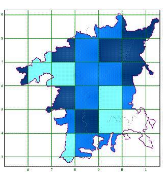
| With all these uncertainties and potential errors, can Domesday tell us much about the quantity and distribution of Worcestershire’s woodland in 1087? The answer is very definitely yes. I have split the hectads into four groups which are mapped right. The darkest colour represents heavily wooded areas, where I am confident that more than half the area was woodland. The next group is the moderately wooded areas with between 15 and 50 percent woodland cover. This is followed by the lightly wooded areas of between 1 and 15 percent and the final group where no woodland at all is recorded. | |
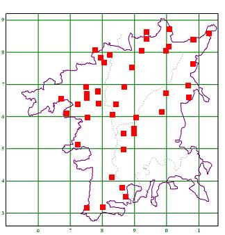
| The place names used in Domesday provide some evidence about woodland cover. The Anglo-Saxon leah indicates a clearing in woodland and is an element in early place names ending in -ley. Names ending in –field (Anglo Saxon feld) were used for usually small fields contrasting with a woodland setting. Other names such as Bromsgrove or Selly Oak indicate some trees but not necessarily large areas of woodland. The map right shows the places where –ley and –field names occur in Domesday. | |
The pattern of woodland names seems to fit the tentative woodland cover map reasonably well. No woodland name places are found in areas without woodland and there are concentrations of woodland names in the areas of heavy woodland cover. SO97 lacks woodland names despite heavy cover and this may indicate that too much woodland has been retained in Bromsgrove rather than transferred to outliers, but could just be that other features of the hectad were used in naming. The lack of woodland names in SO74 is easily explained since there are no places recorded in Domesday between Hanley Castle in SO84 and the Malvern Hills. The lack of any places is further confirmation that this hectad was probably heavily wooded.
There is one hectad where the recorded woodland seems considerably too small. This is SO76 which is shown as lightly wooded. This area has the highest concentration of woodland names in the county, and is now well wooded along the Malvern Axis (Abberley Hills etc) and around the Teme valley. I suspect that some woodland here was not recorded in Domesday. The entry for Astley mentions “woodland that pays nothing” without any indication of area. Other places may have ignored such woodland. It is possible that some of the Malvern Axis woodland in SO76 was included within Suckley without mentioning it as an outlier. This could solve two problems at once by redistributing the excess woodland of SO75 into SO76 but I have found no hard evidence.
I therefore conclude that 11th century Worcestershire was overall well supplied with woodland, but that this cover was very uneven. The southeast corner of the county had no woodland at all. These areas currently have no ancient woodlands and the general landscape has probably not changed greatly in 1000 years. The lightly wooded areas in SO94 and SO95 also seem little changed. The woodland has shrunk here but the picture of small and medium sized woods set in a mixed arable and pastoral landscape was probably as true in 1087 as it is now. SO66 has also probably changed little in appearance over the centuries scattered woodland.
The central spine of the county from Worcester to Kidderminster has shown more change. The three hectads from SO85 to SO87 were quite well wooded. Between a quarter and a half of all the land was woodland. Nearly all this woodland has disappeared, with only a few medium sized woods like Shrawley Wood and Monk Wood remaining. Most other remaining woodlands are small scraps in a farmed landscape. Increased cultivation and urbanisation has removed a high proportion of the Domesday woods.
The heavily wooded areas are hard to imagine. The nearest modern equivalents would be Wyre Forest and the Forest of Dean. In the west nearly continuous woodland must have stretched from below Malvern north to the county boundary. The northeast must have been a pioneering landscape with a few tiny settlements hacked out of a woodland matrix. Nearly all this woodland has now gone, remembered only in tales of the Forest of Arden.
For Worcestershire, Domesday provides a snapshot of a crucial time in the clearance of the original wildwood. In the southeast, clearance had been completed long ago, and different stages of the clearance can be seen as we move north and west. In 1087, the population was small enough not to require huge amounts of farmed land, and the important salt works around Droitwich would have required large amounts of wood to evaporate the brine (Domesday records 500 cartloads a year). After this time the pressure of population growth led to more and more clearance, leaving the county now with less than 5% of woodland cover. Small woods have survived better than the large woodland blocks, except for Wyre Forest, and it seems that the later the clearance, the complete it was.
What relevance does this ancient history have to modern plant distribution? The wild service tree Sorbus torminalis is normally considered to be restricted to ancient woodland but in Worcestershire it is found in hedges in some un-wooded areas. These areas are where there was heavy woodland in the 11th century and our wild service population is a relic from those times. When the woodland was cleared, strips would have been converted to hedgerows, and the trees have survived here through the centuries. Small-leaved lime Tilia cordata shows a similar pattern. Plants such as bluebell Hyacinthoides non-scripta, greater stitchwort Stellaria holostea and dogs mercury Mercurialis perennis are common throughout nearly all the county. The few gaps are either in totally urban areas or where woodland was scarce in 1087.
Plant distribution is determined by many inter-related factors such as geology, soil type, climate and current land use, but the historical factors also have a significant influence. The more we can find out about the changes in the landscape of Worcestershire, the better able we will be to understand and explain current plant distribution. The above examples show that even the situation many hundreds of years ago has left its mark on today’s plants. To ignore the past is to cut ourselves off from an important strand of understanding, and can lead to unnecessary speculation and error.
References:
| MAITLAND, F.W. (1897). Domesday book and beyond. Cambridge. [Reprinted (Fontana, London) 1960 and later] | |
| RACKHAM, O. (1980). Ancient Woodland: its history, vegetation and uses in England. Edward Arnold, London. [New edition (Castlepoint Press, Colvend) 2004] | |
| The sources used for translations of Domesday were Domesday Book 16 Worcestershire (1982). Ed. F. & C. Thorne from a draft translation prepared by E. Whitlaw & Sara Wood, Phillimore & Co, Chichester, and Domesday Book: a Complete Translation (2003). Ed. A. Williams & G.H. Martin, Penguin Classics. |
| WBRC Home | Worcs Record Listing by Issue | Worcs Record Listing by Subject |