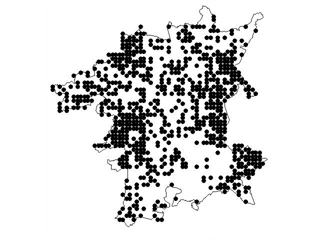
 Figure 1 Worcestershire
Ancient Forest Trees. A coincidence map of Wild
Service Tree, Small-leaved Lime, Midland Hawthorn and its hybrid,
Sessile Oak and its hybrid
Figure 1 Worcestershire
Ancient Forest Trees. A coincidence map of Wild
Service Tree, Small-leaved Lime, Midland Hawthorn and its hybrid,
Sessile Oak and its hybrid By J.J.Day
The concept of Worcestershire Natural Areas was being developed as a framework for the interpretation of the county's flora. This as part of the treatment for the proposed Worcestershire Flora. It became apparent while reviewing the Worcestershire Wildlife Trust's consultation document of selection criteria for Special Wildife Site status, that it failed to adequately address the effects of regionality within the county. These elements coalesced and provided the impetus for the framework presented here.
The concept of biogeographic areas is widely accepted and utilised by ecologists in the study of the natural environment. Indeed it has become so well established that its terminology is used as a matter of course throughout society - tropical rain forest, tundra, alpine plants. The concept can be applied at whatever resolution is chosen - microfloral colonisation of the human body or the Eurasian landmass. Recently it has been used by the Countryside Agencies to produce regional Natural Areas for Britain.
The treatment given here aims to apply the Natural Areas concept at the county level. For the purposes of this paper the resolution is the monad (1km squares). There is a duality of purpose. Firstly to provide a framework for interpretation and understanding of the county's natural environment. Secondly to provide a more rational basis for an integrated conservation policy within the county.
The area covered is the so-called Greater Worcestershire. This is defined as the Watsonian Vice County - VC37, Worcestershire, plus all those additional areas currently within the administrative county. Greater Worcestershire extends over a total of 2177 monads of the national grid. Of these 1707 lie wholly within the area and 470 are part monads. The total area involved is approximately 1933 sq.km.
Nineteenth century botanists tended to divide county's on a river catchment system. These provide firm natural areas and link well with geological and topographical variation. In Worcestershire Edwin Lees used four sub-divisions: Malvern (including the Teme Valley), Severn, Avon and Lickey. English Nature's treatment described six regions occurring in Worcestershire. Both approaches have substantive validity but the resolution is too coarse for a deeper understanding of the ecological processes operating at the county level. If the two systems are overlaid the emerging polygons correlate exceptionally well with the sub-regions described here. Institute of Terrestrial Ecology (ITE) have developed a series of Land Classes for Britain, based on a range of environmental attributes. This at the monad level.
The treatment described here combines the two modern approaches and takes the system a stage further by equating the theoretical land classes/regional areas with the known distributions of vascular plants. It describes the patterns of variation at a more localised resolution based on actual distributions of vascular plants.
So what if any patterns are discernable in the florulas at the monad level? Can these be grouped into natural areas?
In order to have ecological validity, the definition of natural areas (in the sense used here) must stem from the concept of natural vegetional cover. By and large the natural vegetional cover for Worcestershire is woodland. The type and composition varies, due primarily to edaphic factors. Can these wildwood patterns be discerned today and to what extent have they been modified by subsequent human activity? Despite an appalling low woodland cover, in national terms, Worcestershire is essentially a woodland county. Clearance of the ancient wildwood was late. Indeed at the time of the compilation of the Doomsday Book, Worcestershire had the highest percentage cover of woodland in England. My contention and the underlying rationale of this presentation is that the county is in fact still a woodland. Albeit a woodland landscape with exceptionally large glades.
Figure 1 is a coincidence plot at the monad level of forest trees, indicative of ancient woodland (Wild Service Tree, Small-leaved Lime, Midland Hawthorn and its hybrid, Sessile Oak and its hybrid). It is used here as a template of potential ancientness for natural elements in the flora. In broad geographical terms it indicates a link with the wildwood across much of the county. The gaps define the most exploited landscapes: most notably the arable lands of the Vale of Evesham.
Figure 1 Worcestershire
Ancient Forest Trees. A coincidence map of Wild
Service Tree, Small-leaved Lime, Midland Hawthorn and its hybrid,
Sessile Oak and its hybrid
The zones with the strongest links to the wildwood stand out very clearly. The ghost of the ancient wildwood is still very apparent in the landscape. Not all the botanical data be resolved at the monad level so this has reduced the density of plots in the north and central belts of the county. Despite this it provides a valuable indication of the distribution of natural landscape elements.
Figure 2 is a plot of the earliest phases of the Anglo-Saxon settlement of Worcestershire. They settled a heavily wooded landscape. Comparing figs 1 & 2 the imprint of the Anglo-Saxons settlements on the landscape at the start of the twenty-first century is striking.
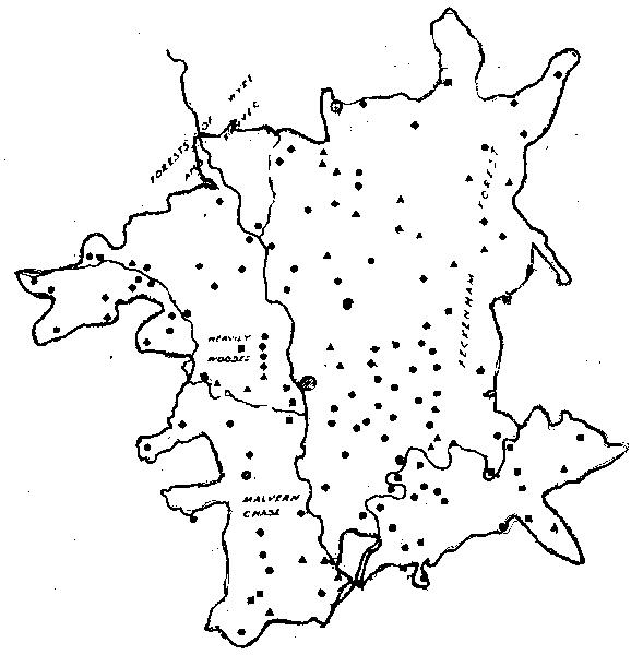 Figure 2. A plot on earliest Angle-Saxon
settlements
Figure 2. A plot on earliest Angle-Saxon
settlements
This is a strong indication that, despite several millenia of agricultural exploitation, the concept of ancient naturalness is still a valid one in the modern landscape. Furthermore it shows that the botanical data can be utilised to model sub-regional variation.
The Worcestershire Wildwood is not at all lost. The saving grace is in the detail. The county is a rejuvenated glacial outwash zone. The natural variation in soils, geology and landform is very complex. This creates a complex micro-pattern of variation super-imposed upon the broad landscape types. For instance the average 10 kilometre square in the county has ten major soil formations compared with just three for Herefordshire.
The convoluted and crenallated landscape has resulted in a super-abundance of minor landscape features ; the dells and dingles, banks and ponds, green lanes and holloways, ancient hedgelines and lanesides. This, when superimposed on the variation in soils, aspect and relief, creates a landscape with an immense variation of micro-habitats for plant colonisation. Tetrad species totals from the current Flora Project suggest that the county is amongst the richest in Britain in terms of floristic diversity per unit area. It is the variation in microhabitats, within the southern climatic zone, that has created this effect. The small scale features have allowed the survival of metapopulations of national signifacance, whether it be great crested newts or spreading bellflowers.
Superimposed upon the natural variation are the effects of land use. Each succeeding wave of fashion in landscape exploitation, during the past two millenium, has left its imprint on the county's biodiversity.
It is stressed that the results presented here are provisional. In essence they are a best fit by eye. The system can not be fully validated until the whole historical vascular plant dataset is transferred to an electronic database. A multiple regression analysis can then be run against all the environment variables to refine and statistically validate the natural areas.
The process of defining natural areas comprised a series of ordinations.
| First the boundaries of the principal geological formation were defined to give primary divisions. This forms the foundation, the bedrock of the system. | |
The Primary Geological Ordinations
| |
| Secondly other natural factors were taken into account - soils, hydrology, altitude, relief and climate. Pre-eminent amongst these was was soil type. | |
| This provided a series of overlapping polygons of potential natural areas.These are indicated by the second numeric character in the natural area lists. | |
| Thirdly, in order to establish which of the environmentally ordinated polygons had a meaningful relationship with floristic variation, distribution maps for the flora (about 2000 taxa) were viewed. These are based upon approximately 350,000 post-1970 records. | |
| This having been established, land use was assessed for its impact on the native flora. In essence, how far has the flora shifted from its original natural composition ? This gave a tertiary division based on anthropomorphic factors. These are indicated by the third numeric character in the lists. |
Much of the pattern of land use both from a socio-political standpoint and an agricultural one, since Anglo-Saxon period, has itself been due to the characteristics of the natural areas. Blocks of landscape frequently retained a unity of tenure and the nature of the soils determined the type and level of agricultural exploitation. The characteristics of modern landscapes can in many instances be traced back to the Anglo-Saxon period. This gives a satisfying unity to the defined polygons when related to anthropomorphic factors.
The natural fertility, workability and hydrological conditions of the various soil types largely determined the nature and level of agricultural exploitation of the various landscapes within different historical periods. Superimposed upon this has been the type of land tenure. For instance, the overall biodiversity of south-east Worcestershire is about 5% less than the rest of the county. If biodiversity is plotted on a map, there is a reasonably clear boundary line. This line corresponds exceptionally closely with the two major ancient landscape types in England - the planned country of medieval strip farming and the the so-called ancient countryside.
This may represent a direct link with the first Anglo-Saxon settlements in the county. The first settlements in the late sixth century were centred on the the Avon Valley. They took place after a major defeat of the British. These settlements may represent the spoils of war for participating soldiery. It is known from place name evidence that there were links with clan groups from eastern England eg Northamptonshire. This presumably established the pattern of land use in this area. Subsequent settlement can partially be reconstructed from charter evidence. This suggests a quite different development based on the rule of law. A top down approach to apportionment: land tenure derived from mainly from royal patronage. A pattern of ownership still traceable in today's landscape. Occupiers have changed: Mercian kings, the Church, Norman kings and lords, industrial magnates, tenant farmers, owner-occupiers, but for much of our ancient countryside there is a direct lineage of tenure to the Kingdom of Mercia.
This dualist pattern of settlement is still apparent today in parts of the third world. Details vary but the patterns are duplicated. For the land-hungry Brazilian peasants carving their subsistance farms from virgin forest read the first indepedant settlements of the Avon Valley. For the large ranchlands of the wealthy landowners, friends of the ruling elite, read the Mercian Kings and The Church. The point being that the imprint of the first settlements lingers with us, apparent today in the patterns of biodiversity.
Urban areas present a conundrum for the definition of natural areas. In this treatment 350 monads (16%) are defined as urbanscapes.
They can not be ignored ecologically. Particularily as biodiversity is frequently higher than in surrounding open countryside.
Natural areas still have validity within urban centres. It is possible to see the natural patterns penetrating through the built environment. Taking Worcester as an example, the garden lawns of Northwick support strong populations of stork’s-bill and the roadsides an abundance of common mallow. These on the river terrace soils. Whereas the mudstones of Warndon support wild service tree and primrose in the relict hedgelines.
In addition to the original florula there is a distinct urban group common to most built up areas. Thus Evesham and Bromsgrove both share a common group of adventives but local variations are also found. Thus the Bromsgrove Sandstones of Belbroughton (the actual Bromsgrove urban flora is pretty dull) have a distinct alpine adventive element, whereas the limestone urbanscape of Evesham has a distinctly Gallic feel. Sunflowers rather than stonecrops.
The urban settlement patterns over most of the county up to 1940 conformed very well with the actual boundaries of the proposed natural areas. Thus Stourbridge was sandstone country, Halesowen on the Carboniferous, Worcester on the river terraces, Bromsgrove on the sandstones. The massive expansion in urbanisation since that time has resulted in a spilling over the natural area boundaries as defined here. Such that all the major population centres now extend over more than one proposed natural area.
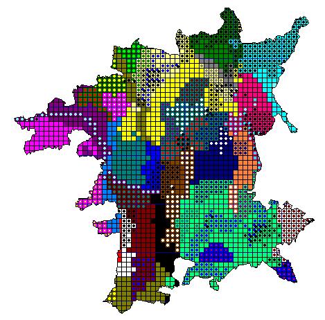
In order to minimise sub-division at this stage, urban areas are probably best viewed as a series of adventive flora overlays superimposed on the existing natural pattern. They are therefore shown as black crosses over the original natural area on figure 3.
| Solid geology fixed the broad boundaries. | |
| This was refined by other natural environmental paramaters. The overiding ones being catchments and soil type. | |
| The distribution maps of the flora were superimposed on these polygons. This provided the regional polygons. | |
| The resulting polygons have been subsequently subdivided based on the current florulas. These equate well with land use history. | |
| The resulting natural areas are listed in the synopsis below. | |
| The resulting natural areas are defined on figure 3. |
| 1 | MERCIAN MUDSTONE GROUP |
| 1.1 | Laugherne Valley |
| 1.2 | Malvern Chase |
| 1.2.1 | The Southern Chase |
| 1.2.2 | The Longdon Basin - Marsh and Ridges |
| 1.2.3 | The Central Chase |
| 1.2.4 | The Northern Chase |
| 1.3 | Hatfield District |
| 1.3.1 | Hatfield |
| 1.3.2 | Warndon and Spetchley |
| 1.4 | The Inkberrow District |
| 1.4.1 | The Eastern Mudstones. |
| 1.4.2 | Bishampton |
| 1.4.3 | Feckenham Bog |
| 1.5 | Salwarpe Valley |
| 1.5.1 | Salwape Valley and Terraces |
| 1.5.2 | Elmbridge Brook Valley |
| 1.5.3 | Hadley Brook Valley |
| 1.5.4 | Hanbury District |
| 1.5.5 | Dordale Valley |
| 1.5.Urban. | Droitwich |
| 1.6 | Arrow Basin |
| 1.6.1 | The Wast Hills and the Weatheroak Ridge |
| 1.6.2 | Mid Arrow Valley |
| 1.6.3 | Arrow Corridor |
| 1.6.Urban. | Redditch |
| 1.7 | Redditch Hills and the Ridgeway |
| 2 | LIAS COUNTRY |
| 2.1 | Avon Vale |
| 2.1.1 | Avon Vale |
| 2.1.2 | The Forest of Horewell |
| 2.2 | Rhaetic Scarp |
| 2.3 | Craycombe and The Lenches |
| 2.4 | Pebworth District |
| 2.5 | The Northern Lias |
| 2.5.1 | Shell Forest |
| 2.5.2 | Kington District |
| 2.5.3 | Hanbury Forest |
| 2.Urban. | Evesham and Broadway |
| 3 | TRIASSIC SANDSTONES AND PEBBLE BEDS |
| 3.1 | Redstone Country - the Bromsgrove Sandstones |
| 3.1 | Urban. Bromsgrove / Catshill |
| 3.2 | The Pebble Beds |
| 3.2.1 | Habberley |
| 3.2.2 | Bissell |
| 3.3 | Bromsgrove Lickey |
| 3.4 | Stour Valley |
| 3.4 | Urban. Kidderminster / Stourport |
| 3.5 | Redmarley |
| 4 | SILURIAN HIGHLANDS |
| 5 | DEVONIAN OLD RED SANDSTONE |
| 5.1 | Teme Gorge |
| 5.2 | The Teme Plain |
| 5.3 | Kyre Forest |
| 5.4 | Gladder |
| 5.5 | Suckley and Mathon |
| 6 | JURASSIC OOLITE |
| 6.1 | Bredon Hill |
| 6.2 | Broadway Scarp |
| 7 | CARBONIFEROUS |
| 7.1 | Wyre Forest Region |
| 7.1.1 | The Wyre Forest |
| 7.1.2 | The Wyre Coalfield |
| 7.2 | Kinver Forest |
| 7.3 | The Halesowen District |
| 7.3.1 | Kenelms |
| 7.3.Urban. | Halesowen and the Black Country |
| 7.4 | Severn Gorge |
| 8 | MALVERNIAN |
| 8.1 | The Malvern Hills |
| 8.2 | The Malvern Commons |
| 8.2.Urban | Malvern |
| 9 | PERMIAN-LICKEY QUARTZITE |
| 9.1 | Clent / Romsley / Waseley Hills |
| 9.2 | Lower Lickey |
| 10 | QUATERNARY. |
| 10.1 | Lower Severn Valley |
| 10.1.1 | Severn Northern Terraces |
| 10.1.2 | The Lower Severn Moors and Meadows |
| 10.1.Urban | Worcester |
| 10.2 | Upper Trent Valley |
| 10.2.1 | Headley Heaths |
| 10.2.Urban | Moseley |
| 10.3 | Avon Plain and Terraces |
It is stressed that the boundaries are not absolute. Indeed minor changes are incorporated whenever the figure is viewed! The figure itself summarises and lumps the data into monads. The precise boundaries of the natural areas obviously cross this artificial grid. At this resolution the monads have in the main been assigned to that zone occupying the greatest area. One distinct natural area, the Rhaetic Scarp, does not appear on the figure. It disappears at this level of resolution. A precise plot of the actual boundaries is in preparation.
 |
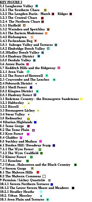 |
Figure 3 Worcestershire Natural Areas (urban areas shown as black crosses)
(Note: If you have a web browser that supports frames you can view an enlarged version of this map)
| Recent work on frequency classes for the native flora highlights a spiral towards extinction within Worcestershire's native florula as a whole. The accumulation of species at the bottom end of the scale is highly marked. | |
| The majority of the native flora is classed as Uncommon. Half of the flora is classed Scarce or Rare. A third is Very Rare or Extinct. | |
| The decline in the native flora has been on a much vaster scale than is currently appreciated. The trend towards a wholly decimated flora is apparent. | |
| It is very obvious that a conservation system based on the preservation of a relatively small number of special sites is a wholly inadequate method for the conservation of the flora. Even a system with 500 sites would leave three-quarters of monads without any protected areas. | |
| It is of course imperitive that special sites are retained. However SSSI and SWS (Special Wildlife Sites) on their own fail to address the issue of retaining viable native populations for most species. | |
| A dual approach is necessary. | |
| Biodiversity is dependant on the wider countryside. In Worcestershire the web of biodiversity is highly dependant upon the minor landscape features. | |
| Only an approach based on landscapes has a chance of retaining the minimum natural capital. |
| Worcestershire is a temperate forest natural area. | |
| Ecologically it can currently be viewed as a forest with extensive clearings. | |
| What is the deviation of the current flora from its natural type? | |
| Take the wildwood flora as a template of naturalness by constructing a potential native flora list for each natural area. | |
Compare this with the current situation for different
ecological groups in the flora.
| |
| This allows an assesment of the impact of land use since the introduction of agriculture. Neophytes (recent introductions) assess recent changes, especially urbanisation. | |
| Model this against both nineteenth and late twentieth century florulas to assess the current situation and trends. | |
| This gives a quantification of the deviation from naturalness within each region. | |
| Regions of high and low naturalness can be identified. | |
| Identify zones for landscape conservation in the case of high naturalness. | |
| Identify zones for landscape restoration in the case of low naturalness. |
A full characterisation is not within the scope of this article. A brief description is given for each zone, and a few areas are highlighted in more detail.
Worcestershire's principal geological formation, it occupies a broad swathe across the county from Moseley to the Gloucestershire border. The surface geology is not simple, especially within Worcestershire's rejuvenated landscape. Two major mudstone formations occur plus frequent skerries, a significant strata of sandstone and a halitic group. They all have implications for floristic diversity, drainage, soil reaction, fertility and agricultural potential. The patterns of variation are complex. Landscape unity is disrupted, such that few of the resulting natural areas extend over more than 30 monads.
A very distinct zone with a uniformity of landscape over a large area. This was wildwood in the period of the first Anglo-Saxon settlements. The uniformity of landscape probably relates to early land tenure. Exploitation was late, much of the area was granted to the church in the ninth century. There is an apparent line of descent to the Witley Estates in the northern part of the area. Clearance to this day is only partial. The wildwood element is strongly represented. It confronts one at every turn.
It is an exceptional area of ancient countryside, quite probably of national significance. This is true forest country. An abundance of ancient pollards. A superabundance of wild service - does any other part of Britain have as much ? All the other ancient forest trees in quantity - small leaved lime, hornbeam, sessile oak, midland hawthorn.
The woodland edge/saum communities are both abundant and incredibly diverse. The lanesides here support the richest saum communities in the county. These communities were overlooked in the original NVC volumes.They have consequently recieved scant attention from conservationists. These are one of the most threatened groups of plant communities in Worcestershire. This is due to shifts in woodland management from coppice regimes and in laneside/hedgebank management. The effect can be modelled by the average Ellenburg light scores for Worcestershire's extinct woodland plants. This is 6.4. It corresponds to plants of partial shade - the edge communities.
Wood margin types are frequent but often very small and highly vulnerable. The superb nature of the saum is epitomised by Bithynian vetch Vicia bithynica. The area is a stronghold for this nationally scarce species. This is the only significant totally inland population in the British Isles.
Other groups also indicate this ancient woodland aspect - a stronghold of the Wood White and Terrestrial Caddis in the county. An exceptionally high breeding density of Little Owls, associated with the abundant pollards. I suspect this could be as dense as anywhere in Britain.
This is ecologically an ancient forestscape of the highest order, a superb woodland resource. It presents problems for conservation. Ancient woodland and veteran trees are frequent but most blocks are very small. They are excluded from formal designations by virtue of their size - they do not show on ancient woodland inventories and are not designated as SWS. Yet these are direct lineages from the wildwood.
This is a unique landscape, a wonderful natural history resource. Special protection should be considered for the whole zone, as a matter of urgency.
This is a very distinct district bounded by the Malvern Hills, the rivers Teme and Severn and the Gloucestershire border. It retained a tenure and landscape integrity well into the modern period. Early exploitation was confined largely to the sandstone ridges of the Longdon area and the spring line of the Malvern Hills. Despite this it is not at all a uniform area. The district as a whole exhibits most of the range of landscape development phases apparent in the county. Its story is a fascinating one. There is an apparent anomaly between late enclosure and biodiversity. Intuitively it might be expected that landscapes surviving say until 1850 would still hold a significantly greater element of their natural biodiversity, than those assarted in 850. This is not normally the case, at least in Worcestershire. Early assarts tended to fix a landscape pattern which has retained much of its integrity to the present day eg the Laugherne region. Late enclosures with greater manpower and machinery tended to wipe the slate clean and produced a very regular field pattern with little semi-natural habitat.
The historical botanical record for the Chase is good and pre-dates much of the enclosures. This was a truly magnificent area for wildlife well into the nineteenth century. Then the axe fell.
The southern portion of the area supports a lower than expected biodiversity. Woodlands are sparse, field size moderate to large, agriculture fairly intensive, hedgelines species poor. Most diversity is in the linear features - lanesides and streamsides. A few relic grasslands of great botanical interest survive mainly in the small tenures close to the commonlands. A reminder of the zone's former glory.
The biodiversity of this area is now one of the lowest in the county. There are a series of ridge lines in the Longdon area , these on the Arden Sandstones. They have a very long history agricultural exploitation ie at least since the earliest Anglo-Saxon settlement. The derived landscape is one of arable and leys interspersed with species poor hedgelines.
The lower land was formerly a very extensive wetland, drained in the nineteenth century. A scatter of small remnant habitats still occur. The landscape is now overwhelmingly one of heavy agricultural exploitation. The great marsh, a rare habitat, was formerley one of the county's wildlife glories. Its drainage a very severe loss to the county's biodiversity. The proposed partial restoration is to be applauded.
Enclosure was late. It was an incredibly rich area in the early nineteenth century. The current condition is of moderately high biodiversity. There are three principle reasons for this. Firstly the nineteenth century estates, notably Madresfield, buffered the area from a total eradication of woodlands. Secondly at the other end of the social scale, the Upton riots, in which several people laid down their lives in defence of the commons. Their legacy, the preservation of some common land in the area. Thirdly, edaphic factors. Much of the land here is on very heavy soils subject to waterlogging. This has reduced the extent and impact of modern agricultural exploitation. Large parts could be classified as a degraded form of the Malvern Common zone.
The northern section has quite a different aspect. The area is reasonably biodiverse. This in part relates to the relief. The stream valleys as they descend towards the Teme are highly incised. In these areas semi-natural habitats have survived. The pattern of both land tenure and farming practice is different. Hop and fruit growing were both widespread. These forms of agriculture were less destructive for wildlife.
This lies between the Severn plain and the Lias scarp. Geologically it is on the Twyning Group of mudstones but with frequent bands of sandstone. The derived soils tend to be fertile and well drained. Consequently the land use is mainly arable. The landscape is derived mostly from the planned landscape. The hedges tend to be of enclosure age. Semi-natural habitats are sparse and centred mainly on the old estate lands, especially at Croome and near Spetchley. Biodiversity is moderate to low.
A significant area in the north of the zone is on alluvial soils. Here the drianage is poor below the Lias scarp. In the mid nineteenth century they held significant marshland interest. Now virtually eliminated. A possible candidate for landscape restoration.
Most now lies under the city of Worcester. The mudstones here produce a heavy soil subject to waterlogging and it was predominately pastoral country in the past. A transitional type between the planned and ancient landscapes. Hedges mainly date from the enclosures but with pockets of more ancient habitats.
Geologically this area overlays a mixture of Mudstone and Arden Sandstone. The soils tend to be drier and more fertile than on most of the Mudstones. Arable farming is more evident and semi-natural habitats relatively sparse.
This area has been singled out on the basis of modern land use. It is, perhaps, the most decimated landscape on the mudstones - in terms of biodiversity. Intensive arable farming the causal agent.
After Longdon Marsh this was formerley the most extensive wetland system in the county. It lies on a mosaic of alluvial and mudstone formations. Reconstruction of the plant communities from the known losses suggest a superb basic fen with affinities to the Broadlands of East Anglia. Several NVC communities were lost to the county with its destruction due to drainage. Only a tiny remnant remains - on the WWT Reserve, Feckenham Wylde Moor. Despite this the area can still be isolated from the surrounding landscape by its extant flora.
This is the central area of the Worcestershire Mudstones within the Salwarpe catchment.
A distinitive zone running from Stoke prior to the Severn confluence. The limit is taken as the extent of the river terrace deposits. Where relief allows these tend to be intensively farmed. However much of the valley is steep side especially downstream of Droitwich and a more diverse flora is apparent in association with the valley side - scrub, woodland and grassland. The flood plain habitats are unique in the county. The area was renowned for its salt deposits and there is a distinctive brackish element present throughout the valley system in association with the river, the canal and on the remnant wetland habitats on the flood plain - species such as Wild Celery and Dittander occur. The salinity levels have dropped since the 1960s and several halophytes are now extinct. Pimpinella major has its stronghold here.
| 1.5.2 Elmbridge Brook Valley | |
| 1.5.3 Hadley Brook Valley | |
| 1.5.4 Hanbury District |
This zone is relatively uniform floristically. The subdivisions relate to land use and its impact on biodiversity and the quantity of semi-natural habitats. The zone has a relatively low overall biodiversity. Most is concentrated in the valley bottoms. There are significant pockets of ancient woodland scattered through the area.
The low diversity probably stems from a long history of agricultural exploitation. This dates back to at least the Romano-British period in the case of the Hanbury area and to the earliest Anglo-Saxon settlements in the case of Elmbridge. The Elmbridge pocket is on more fertile soils suggesting a link between one of the lowest biodiversity scores outside of southeast Worcestershire and the earliest phase of Anglo-Saxon settlement.
This is a very distinct zone of ancient countryside. A landscape of woodlands and meadows sited at the limit of the mudstone lands. It takes in the headwaters of the Hadley and Elmbridge Brooks. It stands in marked contrast to the more planned landscape of these lower valleys. Soils are less fertile, heavier and pockets of drift deposits occur. The relief is higher and the valleys incised. Biodiversity is high and ancient woodland cover very high. The zone is predominately wooded or pastoral. Much of the zone is outwith conventional agricultural practice, which accounts for much of the high diversity. Particularily in regard to the significant concentration of unimproved grasslands. One of the richest remaining zones within the mudstone area.
Droitwich lies mainly in the Salwarpe Valley Natural Area. Its principle ecological interest is centred on the Salwarpe corridor, which supports a very interestig range of habitats.
Formerley a part of the Forest of Feckenham. Settlement was based principally on the church lands of Bordesley and Alvechurch. Woodland clearance was late.
A very distinctive glacial outwash basin marked on eastern side by the Wast Hill/Weatheroak scarp and on west by the Redditch hills and Lickey. It supports a northern variant of the mudstone flora characterised by the abscence of a number of species. In particular the basic element such as wild basil, Clinopodium vulgare. Sandstone skerries are frequent giving a more mesotrophic feel to the flora.
Woodland is very sparse indeed. Despite this the ancient woodland element is still strongly represented. Wild Service is more abundant here than in any area other than Laugherne. A characteristic feature is an abundance of marl pits. Their wooded banks are one of the principal elements in the survival of the ancient woodland flora.
The next three sub-zones do not translate well to a monad treatment and are not shown on the figure of natural areas.
Largely a landscape of agriculturally despoilt pasturelands with a very low woodland cover. Despite this the late nature of the woodland claearance is still apparent in the flora. These elements are now mainly confined to the holloways, marl pits, hedges and bridleways. An area with a striking potential for landscape restoration. Especially as it forms such a prominent landscape feature.
An attractive mudstone landscape, with many minor features of ancient countryside. Despite this biodiversity is relatively low and is, in the main, confined to the minor features. This is consistenet with a phase of clearance and enclosure within the modern period.
The basin floor. This incorporates most of the lower lying portions of Redditch including Ipsley Alders. The principle floristic interest is centred on the Arrow corridor which includes a substantive number of semi-natural habitats, particularily in Redditch.
A floristically very distinctive zone. There is a mosaic of mudstone and glacially derived soils. Till and glacial gravels cap the highest ground giving a meso-oligotrophic element to the flora, uncharacteristic of the mudstone florulas eg Calluna vulgaris, Luzula sylvatica, Vaccinium myrtillis. This is a well wooded area extending into the Redditch urban zone on its eastern side. Large leaved lime, Tilia platyphyllos is the outstanding component of the woodland flora. Outlying pockets occur at Rowney Green and Barnt Green.
An important natural area.
The urban zone extends across several natural areas. Redditch has a fascinating florula. The landscape was effectively frozen in the late 1960s. The area consequently avoided a significant episode of agricultural intensification. Despite the construction of a new town the native florula is largely unaltered from that described by Fincher in 1966. In large part, due to his Ecological Survey most of the important ecological features were retained, along with much of the minor habitat infrastrucure - ponds, hedges, greenways.
Superimposed on this is an incredibly extensive and diverse alien flora, particularily of trees and shrubs. The whole effect is that of a massive ecological experiment - the alien and the native. Already after only 30 years the new town has a highly distinctive exotic flora. The whole aspect of the area is of woodland.
At such an early stage in the succession and within an urban area there are many uncertainties. The biodiversity is already high and the proportion of semi-natural habitats impressive. If the depreciations on the county's wider countryside continue then it is predicted that Redditch Urban could become one of the foremost hotspots for biodiversity in the West Midland Region.
The Lias dominates the southeast portion of the county. This is the most intensively farmed part of Worcestershire. The soils are mainly derived from calcareous clays which provide fertile soils on the better drained areas. The microclimate is warmer and more sheltered than most of the county. The area has seen significant agricultural exploitation since the bronze age. Important concentrations of biodiversity occur to the north of the area and around the Lenches. Away from these, this is generally the poorest part of the county for biodiversity.
This is the most intensively cultivated area in Worcestershire. Semi-natural habitats are decidely restricted and biodiversity is the lowest in the county. Soils are calcareous and several ruderal species are restricted or at their greatest abundance here. It is perhaps fitting that probably its most characteristic species is an adventive - wild asparagus. A common weed throughout the Vale landscape.
There is the potential for further sub-division on land use grounds. For instance, the area east of Evesham is to all intents and purposes a diffuse urban zone, with market gardening the dominant land use in the open areas.
This area stands out from the rest of the Vale in its concentration of semi-natural habitats. Notably the forest remnants of the ancient Forest of Horewell and some unimproved common land. The concentration here of this important series of habitats relates to the tenure of the Croome Estate. It provides a valuable template against which to quantify deviation from naturalness within the Vale landscape.
The boundary between the Mudstones and the Lias is marked by a narrow scarp. This is too narrow to allow definition on figure 3. Despite this it stands out floristically as a very distinct natural area, with considerable wildlife interest. Bands of limestone has given rise to a highly characteristic calcareous flora. Although now very fragmented, calcareous grassland and woodland are its principal semi-natural habitats. The relief has restricted the level of agricultural exploitation.
A very distinct landscape area. This is the higher ground on the northeast side of the Vale. Characteristic landscape elements include a varied relief, a large area of woodland and although much reduced fruit production.
Biodiversity is good, the flora calcareous, habitat diversity good. Several species are restricted to this area eg Gentianella anglica.
Whilst still a good area for wildlife, it lost a considerable area of habitat, of county significance, in the late twentieth century.
At first sight this area appears very similiar to the rest of the Vale. It is similiarily low in terms of overall biodiversity. However it varies in several respects. Floristically there are subtle differences.The soils tend to be heavier and grasslands more frequent. The ridge and furrow here is of the highest amplitude in the county.
An area of ancient landscape characterised by - an extensive area of woodland distributed throughout the area as discreet blocks ; a high portion of pasture and meadowland ; small field size interspersed with old hedgelines. The area is on a heavy calcareous clay soil of low fertility. It has high biodiversity and is important for its ancient woods and unimproved meadows. The core area for a number of localised species. An exceptionally fine area of ancient countryside.
This is a transitional region. It is similiar to the forest land to the north in regard to landscape infrastructure and shares common floristic elements. It is similiar to the vale landscape in its lack of woodland and a more obvious arable component in the landscape. Its principal floristic interest lies in its remnant grasslands, which includes a strong calcareous element.
The northern outpost of the lias. This area is best viewed as an agriculturally despoilt part of the greater forest area. Field size is large, arable is the prelevant land use and biodiversity low. This in contrast to its early history. The area here defined corresponds very closely with the original Hanbury Park, a royal hunting forest.
These urban areas stand out floristically for the adventive floras associated with the locally sourced Cotswold limestone. Both exist as small nucleated towns within a diffuse urbanscape extending over a considerable area.
There are three principle sandstone formations. The derived soils are light and sandy. Most produce high grade agricultural land. Consequently the intensively farmed landscape has little semi-natural habitat and low biodiversity. The area has also suffered from water abstraction to the extent that the stream corridors frequently support only degraded habitats. The less fertile formations, mainly to the east of Kidderminster, have acid soils with heaths and woodlands.
From the evidence of the remnant ancient woodland, it appears that small leaved lime was a major component of the original wildwood. Clearance was apparently fairly early.
An irregular belt of red sandstone country running across north-central Worcestershire. The light well drained soils have produced a landscape heavily exploited by agriculture. Woodland is sparse, biodiversity low. Most natural areas are small. They tend to be confined to scarps, bluffs, rock outcrops and the valleys. Special plants include Campanula patula and Hypericum montanum.
This is perhaps the least interesting urban area in Worcestershire. There is very little semi-natural habitat. The flora is very limited.
The lands between the River Stour and the Wyre Forest Coalfield is a distinctive landscape. The relief is varied and the area is well wooded. This is relic Forest country derived from the Forest of Kinver. Biodiversity and the area of semi-natural habitats is high. The wood heath communities are its outstanding feature (Habberley Valley, Devil’s Spittleful and Blakeshall Common). The locus for several rare plants. A national stronghold for Arabis glabra, the nationally rare grass Corynephorus canescens and the county stronghold for the white mullien Verbascum lychnitis.
The pebble beds to the east of Kidderminster are heavily exploited by arable farming. Biodiversity is low and semi-natural habitats sparse. On landscape and floristic grounds there may be a case for amalgamation with the redstone landscapes of the Bromsgrove Sandstones.
There is a distinct zone of pebble beds forming the the foothills to the Permian highlands. The agricultural areas support little semi-natural habitat and have low biodiversity. However a major section has been developed as low density housing on the fringes of the Lickey Hills. The major portion of this ghetto is inaccessible, being within the extensive grounds of private residences. For this reason its contribution to the county's biodiversity has been overlooked. Landscaping has defiled much of the formerly extensive semi-natural habitats, despite this it is highly probable that the zone still supports significant populations of many acid loving species. Some plant species eg the clubmoss Lycopodium clavatum considered to be extinct in the county could still linger here. The whole area has an aspect of open woodland, with many mature trees. It is predicted that its faunal communities are of exceptionally high conservation significance in a county context.
The valley of the Stour and its eastern tributaries present a very distinct natural area. Here are the county's greatest concentrations of wetland habitats - open water, marsh, fen and carr. Biodiversity is high. Despite this there has been a very significant decline in quality since 1970. The principal components of this are drainage, eutrophication, water abstraction and creeping urbanisation (tips, houses, roads, parks, assarting).
The zone may have national/international historical significance for its place in the earliest phases of the industrial revolution. It is still an outstanding natural zone in county terms but the trends are very obvious.
These urban areas have almost coalesced. Most of the wildlife interest is centred on the Stour Valley. In addition there are some valuable grass-heath habitats.
There is a small pocket of Bromsgrove Sandstone in the extreme south west. Despite its size, it nevertheless supports a most interesting florula. Biodiversity is good and there is a high proportion of semi-natural habitats. The florula is rich and several scarce plants occur - Hypericum montanum, Campanula patula. Away from the Severn Gorge it is probably the most natural landscape area on this geological formation.
A very distinctive and well defined natural area. This is the series of hills and low ridges running north from Mathon to the Abberley Hills. The underlying strata are predominately Silurian Limestones such that the flora is predominately basic. The geology is not simple and the presence of sandstones, Permian and even Malvernian rocks adds diversity to an already very rich flora. It is an incredibly rich area. The vast majority of the landscape is clothed in semi-natural habitats with a series of ancient woodlands forming the core interest. These are some of Britain's most diverse woodlands in terms of their tree and shrub component. Large-leaved lime is present over much of the range and hornbeam is on the edge of its native British limit here.
An exceptionally high quality landscape for biodiversity.
The florula of this region varies in a number of repsects from much of the rest of the county. A number of otherwise common species are generally absent here Bryonica dioica, Silene latifolia; others such as Geranium pratense are at their most abundant.The different soil characteristics account for much of the variation but climatological differences have some influence. Biogeographically it is a part of the Herefordshire region.
This landscape in terms of both visual quality and biodiversity is quite simply magnificant. It appears quite out of keeping with the landform characteristics of the rest of the county. But a great flood of devasting proportions passed this way. In doing so it carved out a great strath and rejuvenated all the rivulets and streams in its wake. Its outstanding ecological feature are the extensive woodlands. These exhibit the full range of edaphic variation from acid to basic and wet to dry. In addition the tufa springs and deposits are a nationally important resource. These woodlands are superb. Despite this only a small proportion and not all the best examples have been given statutory protection. A most diappointing state of affairs.
The river itself and the valley floor habitats (where they survive) support a very distinctive florula throughout the length from Little Hereford to the Severn confluence. For this reason it is given a sub region of its own. Interestingly there are many common features with river systems of the Scottish Border country - Scirpus sylvaticus, Scrophularia umbrosa but with a distinct southwest British element as typifed by Aconitum napellus. The Teme is the best British river for a number of different groups.
A superb natural zone.
This is the plateau landscape of the old red sandstone. Most of the area drains into the Kyre Brook which flows through a broad basin. The diversity of semi-natural habitats is good with a significant proportion of ancient woodland. Where conditions allow arable is a prominent feature.
The old red sandstone area south of the Wyre Forest. A landscape heavily exploited by arable farming. Biodiversity and semi-natural habitat area are low. The zone is saved from total agricultural annilihation by a a series of rejuvenated valley systems based on the Gladder Brook. These steep often wooded valleys hold a rich flora similiar to the Teme Gorge woodlands.
Two small areas to the west of the Silurian highlands. These, from both an ecological and geological perspective, belong with the Herefordshire landscape to the west. The landscape is one of mixed farming, moderate field size and old hedgelines. Biodiversity exists mainly along the stream corridors.
This is typical Cotswolds country. The well drained calcareous soils support many species which are restricted to this zone eg Campanula glomerata, Hippocrepis comosa, Polygala calcarea. Differential species between two areas, such as the arable weed flora of Bredon Hill, relate mainly to land use. Both areas have high biodiversity.
The principal lost habitat has been calcareous fens associated with the spring line. This group of species is entirely lost.Grassland is also much reduced.
The scarp slopes hold most of the semi-natural habitats - limestone grassland, woodland, calcareous scrub, parkland. Old quarries and the arable lands also hold significant communities.
Woods and grasslands support the principal floristic interest.
There are two blocks of landscape sited on the Carboniferous formations. Their florulas differ quite markedly. The most obvious being due to the more acidic nature of the soils in the Wyre region.
The vast majority of this area is woodland, although there are significant areas of forest edge habitat such as umiproved grasslands. The majority is on acid soils although the steam valleys add considerably to the biodiversity in the provision of more basic conditions.
The area is outstanding in a regional context for its woodland communities.The forest area supports significant populations of many county rarities Geranium sylvaticum, Carex montana, Melica nutans. Despite the survival of an extensive area of high value, semi-natural habitat, the forest zone has been severely degraded since the mid nineteenth century. It has experienced a considerable decline in biodiversity over the past 150 years.
In the period up to 1970, at least 54 taxa had been lost from the forest area ; 26 of these are also VC37 extinctions. This represents 25% of all county extinctions from just one site.
The county extinction rate is 11%. If the Wyre Forest could have been frozen in its 1830 condition the county extinction rate would be have been reduced to only 8%. The high loss rate here can be attributed to land use changes within the Forest - the cessation of coppicing, peripheral encroachments and enclosures, sucessional changes, loss of bogs and pools, deer grazing and last but certainly not least coniferisation. The story here is one of steady degredation and a continuing attrition as special microhabitats are lost one by one.
Even within high value wildlife areas the need for conservation of the minor landscape features is highlighted.
The agricultural belt southwest of the Forest. Part of the former coalfield area, with some semi-natural habitats derived from mining. An area of mixed farming with a reasonable biodiversity. A plateau area with most of the natural history interest in the well wooded draining valleys.
This is the land east of the River Severn bordering on Staffordshire. It is an ancient landscape, heavily wooded. Geologically complex it includes Carboniferous, Devonian and volcanic formations. It is seperated on floristic grounds from the main block of the forest by a more varied flora with a significant basic group of species.
This is the rural landscape sandwiched between the Permian highlands and the Halesowen urban zone. It is a very fine area of ancient countryside with a high density of ancient woodland sites and a significant number of unimproved grasslands. Although on the carboniferous the florula differs markedly from the Wyre Forest Coalfield. There are more basic soils. The one plant which characterises the area more than any other is Water Avens Geum rivale, currently confined in the county to damp ancient woodland communities within this zone.
A geologically and topographically complex area with a fascinating florula. The vast majority of the area is urban but significant pockets of ancient habitat remain such as along the Stour valley. In a county context the outstanding feature is probably the canal system which supports unique and rare species assemblages. Pockets of sandstone country with acidic floras occur - notably around Stourbridge and at Warley.
Between Arley and Holt the River Severn runs through an impressive gorge. This is essentially a wooded landscape with a very considerable wildwood element. Exposures of substrata has allowed the development of a range of woodland communities, some not found within the main block of the Wyre Forest. Small-leaved Lime woodland is frequent and reaches one of its maximum British expressions at Shrawley Wood.
The valley floor is narrow and its wetland interest increased by a series of valley floor wetland habitats of considerable interest. Some of these are the best examples of the swamp woodland habitats left in the county.
Biodiversity is exceptionally high. The proportion of semi-natural habitats is amongst the highest in the county for a natural area. There is the potential on geological grounds for sub-division. A split into two sub-zones based on the sandstone country would make ecological sense. However the area forms a continuous natural unit linked by the river and is probably best viewed as one zone with high natural diversity.
On a unit area basis this is the most floristically diverse area of the county. The survival of so much of its distinctive landscape is a testament to the activities of the original Malvern Hills Conservators - one of Britain's first conservation lobbies.
The Hills form the core element but much of the lower ground is on head derived from the Malvernian rocks. The lower ground florula is very distinct. So much so that it constitutes a distinctive natural zone. As its origins lie with the Hills rather than the mudstones it is included here.
The enclosed Central Chase area is on a mosaic of head and mudstone. It could be incorporated here as a degraded Malvernian type. Most of the Malvernian specialities are entirely lost and in now fits better a mudstone type.
Biogeographically the area is unique. The natural flora, in its juxtaposition of species and communities is unlike any other part of Britain.
Virtually the whole hill system is semi-natural habitat. Acid grassland, scrub, woodland, grass heath being the dominant types. Most of the area is on acid soils but important pockets of basic conditions are found. The area is very rich botanically and includes several national rarities.
The majority of these are lost either to urban Malvern or the agricultural enclosures. A significant area yet remains. The Castlemorton/Hollybed/Coombe Green complex is a superb area. The richest botanical area in the county with many rarities, including some of national importance.
All the other remaining commons hold some botanical interest, including rare species. Unfortunately all are also very degraded. There are many causes but paramount on botanical grounds would appear to be eutrophication. It is interesting to note that the Castlemorton complex does not figure in the historical record as being the richest. The full analysis has not been completed but the Malvern/Barnards Green complex was probably the richest.
The settlement at Malvern and its botanical impact was small up until its development as a spa centre in the Victorian era. It has experienced steady growth since that time.
Malvern was a mecca for early botanists. So much so that virtually all British herbaria hold some early Malvern material. Two of the county's foremost botanists Edwin Lees and R.F.Towndrow resided here. The consequence of all this activity is a remarkably detailed record of its flora spanning the whole period pre and post enclosure development. This fine historical dataset allows an analysis of the impact of urbanisation within an area still supporting a considerable proportion of semi-natural habitat.
A comparison between SO73 and SO74 is very revealing. The former has a settlement pattern similiar to the mid-nineteenth century, whereas SO74 has seen the growth of a large urban population. They are similiar in other respects - size, geology, soils, climate.
Percentage loss of native flora 1750-2000
| SO74 | 17% |
| SO73 | 7%% |
Worcestershire hectads average: 12%
The losses due to urbanisation are in the order of 10%.
This is the hill system extending from Clent Hill in the west to Barnt Green in the East. A significant proportion of the area is public open space centred on the country parks. The soils vary from meso to oligtrophic, with acidic substrates predominating on the hill tops. As most of the county is on eu/meso to eutrophic soils this hill series adds a distinctive and valuable contribution to the county's biodiversity. This can be illustrated by the rills draining the hills. These tend to be very small, often seasonally dry and heavily grazed. They have never been acknowledged as being of any particular conservation value. Yet they provide the county's main locus for Ranunculus hederaceus (figure 4), often in association with Montia fontana.
The wetland mesotrophic element in the flora has been decimated over the past 50-100 years by eutrophication. These apparently insignificant little rills therefore assume a high conservation value in representing one of the few links to the less defiled wetland landscapes of earlier periods. This pattern of minor landscape features providing the locus for biodiversity is repeated time and time again in the county. The ponds, banks, springs, verges, rills, copses are the foundation of the county's biodiversity. Yet very few have any formal conservation whatsoever. They are passed over or ignored, their value unrecognised. Yet if Worcesterhire is to maintain its minimum natural capital it is imperitive that they are brought on board. The obsession with site protection, the 999 approach, understandably took precedence in the face of the wanton destruction of the post-war period. Species conservation is now absorbing much time and money. Species and habitats do not exist in isolation. They are sustainable only as part of the landscape. Only when conservationists address themselves to landscape conservation can there be hope for the maintainance of viable wildlife populations.
Much of this hill series is semi-natural habitats. The grasslands, grass heaths and minor wetlands provide the loci for its main contribution to the county's biodiversity.
The Lickey quartzites give rise to oligotrophic, skeletal soils with a low ph. They hold a very distinctive florula in comparison to the rest of the hill series and are consequently recognised as a natural area in their own right. The species assemblages of the Lickey heaths where not decimated by tree planting are a unique resource.
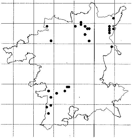
Figure 4. Ranunculus hederaceus. This figure picks out quite clearly the Permian Hills , Headley Heaths and the Malvern Common Natural Areas. It also defines fairly precisely the tiny remnants of mesotrophic aquatic habitats in the county.
This is the flood plain and river terrace deposits from the confluence with the River Salwarpe to the Gloucestershire border. The flood plain gradually broadens south from Holt as the Severn matures in its lower reaches.
The principal defining characteristic of this area is the river terrace deposits. These are enormous. The late glacial Severn, Salwarpe and Teme shed much of their loads of glacial outwash gravels in this area of confluences. The light, well drained soils close to these major watercourses provided the locus for the growth of the City of Worcester. Floristically the gravels are well marked, with the botanical highlight being the main site for Meadow Clary in Worcestershire - a metapopulation deep within the city limits. The River Severn flood plain gradually broadens through this area. Despite development it still holds considerable botanical interest. Outwith the city area the terraces are mainly arable with low biodiversity. Although this is to some extent offset by a series of fine habitats on the scarps above the watercourses.
The title for this area has a distinct nineteenth century ring to it. In the early nineteenth century it was most probably superb for wildlife. A series of gravel ridges stood out on the flood plain, surrounded by extensive grazed marshland and bog and fronted towards the river by a series of large ham flood meadows. All bordered on the west by a pristine eutrophic river famous for its abundance of migratory fish. Today its glories lie more in the imagination than in the landscape. The gravel terraces are intensive arable fields, the hams ploughed or sprayed out, the bogland drained, the river a navigable canal. Its interest today lies in the remnant examples of these habitats. In terms of the modern county these are still fairly extensive and biodiversity still moderately good. Its characteristic plant, Oenanthe silaifolia, although much reduced still occurs in some quatity at a number of sites. This is another landscape which cries out for restoration.
The urban area extends mainly over two natural areas, The Northern Terraces and Warndon. That is the terraces deposits on either side of the river and the mudstones to the east. Most of the native floristic interest is centred either along the floodplain or on the series of low hills and ridges to the east of the city.
This is the high ground to the north and east of the Lickey watershed. It occupies the valleys of the rivers Rea and Cole. Solid geology is Mercian Mudstones but the majority of the area is overlain by till producing a very distinct flora. There are many plants eg Sanguisorba officinalis, Salix pentandra which it shares in common with the marginal uplands of northern England eg the Pennine fringes. It formerly held the only blanket mire communities in the county.
It is subdivided into two zones. Headley is a rural landscape. The northern part, Moseley, is urban and forms the southern portion of the Birmingham conurbation.
This is that part of the area not yet absorbed within the conurbation. The so called urban fringe. Land use is varied as agriculture has retreated in response to people pressure. The small pockets of arable produce a distinctive weed flora. The early post-war agricultural retreat has left many traditional habitats in its wake. Its botanical highlights are the damp areas and old meadows with such county notable species as Cirsium dissectum and Carex elongata. Mesotrophic wetland remnants are commoner here than anywhere else in the county.
Despite a rather poor PR image the urban zone has a relatively high biodiversity. There is still quite a substantive area of semi-natural habitats, particularily associated with the river valleys. It is perfectly possible to walk all day within greenspace over much of this zone. The adventive element in the flora is strongly represented. Floristic subdivision may be possible - seperating the till areas from those on the valley sides and bottoms where the mudstones have been denuded.
This forms a very distinctive floristic zone through the Vale. Not only in the wetland species associated with the valley floor but with the flora of the terrace deposits. In effect this natural area is equivalent to the late glacial river. Floristically the Avon is the richest eutrophic river system. It banks and flood plain hold some important meadowland and wetland sites. A significant population of the nationally scarce Large Dodder is found along the banks. The terraces are mainly arable. This supports a ruderal community not found elsewhere within the Lias zone. It provides a welcome enclave of biodiversity within a heavily exploited landscape.
 Sorbus torminalis
| WBRC Home | Worcs Record Listing by Issue | Worcs Record Listing by Subject |