 |
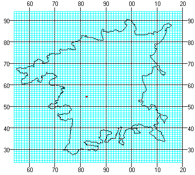
The National Grid system works on a
system of squares of differing sizes. First, the whole
country is split into squares of 100km by 100km.
Worcestershire falls into two of these: SP and SO. The
red dot is in SP. Places to the right of the 00 line are
in SO.
The black lines split the area into 10 km squares, and
the red dot falls into 10 km square SP85 - the 8 is from
the top or bottom edge of the map, and the 5 from either
side.
The blue lines split the area into 1 km squares, and
the red dot falls in square SP8254 - the 82 again from
the bottom or top of the map, and the 54 from one or
other side.
|
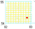
| If you give a grid reference for the 1km square where
you found your specimen, this will be accurate enough for
many records. All of the 1:50 000 Landranger maps and the
1:25 000 Explorer maps have 1 km squares drawn on them (in
black, not blue like these), and the numbers for the
squares along the top, bottom and sides, as well as
somewhere in the middle to make life easier. |
|
| |
To remember which number to quote first, think that
you have to go 'in through the door' , that is across the
map, before you go 'up the stairs'. |
| If you need to give a more accurate grid reference
for something rare, then you have to imagine that your 1
km square is divided yet again into 100 metre squares -
10 squares in each direction, as shown by the yellow
lines, and then add an extra number in each direction.
The red dot is now in SP 828 542. This is a six-figure
grid reference. |
 |