Paul Mousley
Introduction
In early 2002 I was commissioned by the Worcestershire Wildlife Trust to conduct a survey of native Black Poplar trees Populus nigra var betulifolia in Worcestershire. This survey was to build upon the work previously carried out by the Environment Agency and the Worcestershire Flora Project in order to gain a better picture of the status of the species in our county.
The Black Poplar is one of Britain's rarest and most endangered trees. We are lucky that in Worcestershire to have one of the densest populations in the country. However, there is estimated to be no more than around 1000 in Worcestershire, and only 7000 nationally.
Despite being recognised as a Red Data Book (RDB) endangered species and it's inclusion in the Biodiversity Action Plan (BAP), comparatively little is known about the species compared to other more common trees such as Oak Quercus spp. and Ash Fraxinus excelsior. More research is clearly urgently needed in order to establish a knowledge base for the species.
In a more local perspective the various species lists and surveys that have previously been carried out show a number of different estimates of the numbers and distribution, etc. across the county. This situation needs to be clarified in order for any serious conservation strategies to be considered.
It is evident that conservation of the species needs to begin and be focussed in the right direction, and this direction needs to be established.
The objectives of the survey were as follows:
1 To confirm that current recorded black poplars are still valid
2 To find any new trees that may be waiting to be discovered
3 To gain information about the current status of the population
4 To establish a comprehensive database as a working record of the black poplar in Worcestershire
5 To use the knowledge gained from the survey to make recommendations for future management of the population
Methodology
In order to meet the objectives above, a survey of the currently known trees was undertaken and the information gathered entered into a database. The trees were located and the following measurements/observations taken: an eight figure grid reference of their location; height; girth (Diameter at breast height (DBH) (1.4m)); sex; health class (Healthy, Fair, Poor or Dead); age class (Immature, Mature or Over-mature/Senescent); management regime; and adjacent land use. In addition, a sketch was made of each tree and a small scale sketch map was drawn to pin-point its location in the landscape so that it could be easily found in the future.
This data was then used to establish information about the population and its needs. This can then be used to establish recommendations for the management of the species in the future.
Results and conclusions
The survey is only approximately one quarter complete (the southern part of Worcestershire), however, there are some interesting preliminary observations and conclusions which can be made.
Only 29 (10%) of the trees surveyed were present in the Environment Agency list and 63 (22.5%) were present on the Flora Group list. This confirms that the survey is indeed a vital part of the conservation of the trees and is a very positive sign that there may be more individuals in the county than was anticipated.
Due to the difficulty in accurately establishing the gender of many individuals the data is incomplete, however, it is known that of the 279 trees surveyed; 58 are male and only 5 female. This obviously raises series questions as to the ability of the species to retain genetic diversity via inter-breeding. It should also be noted that thus far, to our knowledge the male and female trees are extremely spatially separated, which will inevitably compound the problem.
The trees surveyed range in height from 0.5m to 45m with an average height of 16.59m and the diameter ranged from 0.02m to 6m with an average diameter of 2.91 metres.
In terms of age the great majority of the trees surveyed (76%) were mature individuals, with very few (14.7%) young trees available to follow these as they fall into senescence, an area which clearly needs to be addressed when conservation is considered. Young trees were found to have been planted as stakes cut from their older neighbours, and were only found on Castlemorton Common, leaving the rest of the county in significant need.
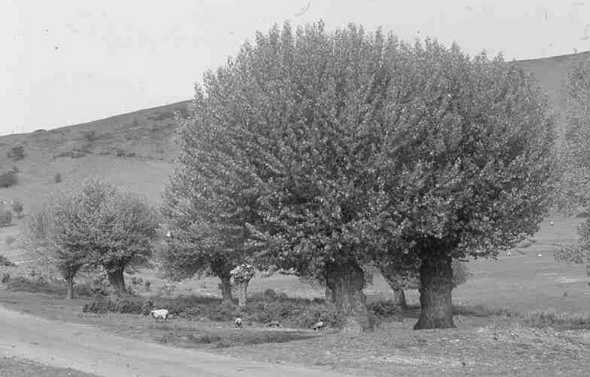
Pollarded black poplars round a pond on Castlemorton Common. Photo G H Green
The majority of trees (82%) were found to be in good health, which is extremely encouraging as it indicates that the population is in a relatively stable and viable condition at the moment, and there is time for conservation efforts to be planned and put into place.
A total of 56 (20%) of the trees surveyed were hollow, which is encouraging as the evidence seems to suggest that black poplars are less hardy than, say, the crack willow Salix fragilis and tends to fragment and decline when it becomes hollow.
The frequency of management ranged from less than one year to 65 years, with an average of nine years. Around 40% of the trees surveyed are under current management. The continued management, particularly of the pollarded trees is an important factor when considering the conservation of the population and efforts should be made to increase the numbers that are being managed. It has been observed that the excessive weight of the large bows on neglected poplars compounds their tendency to fragment under stress.
As most of the individuals are found in a rural setting, the majority are found in close association with hedges and fields. It is broadly accepted that the black poplar is a water loving tree and this is supported by the fact that nearly 64% of those surveyed were found in close association with water courses, ponds and ditches.
The following species are commonly found in association with the Black Poplar: Ash, Beech, Birch, Black Poplar, Elder, Field maple, Hawthorn, Hazel, Holly, Oak, Pear, Sycamore, Willow.
The distribution of the population tends to be concentrated into large groups of individuals, with comparatively few lone trees in the landscape (see distribution map). There seems to be a denser population towards the SW of the county, which thins out towards the west. Similarly, the population appears to be denser in the south. This trend is only a preliminary conclusion, however, and will be given greater resolution as the survey continues. The largest concentration found thus far is on Castlemorton Common, which has large numbers of individuals (nearly 160) along its many streams and around its many ponds. This site is also the only area where significant planting of stakes takes place in the county and as such there is a range of ages and sizes of trees. The map also illustrates that records of the trees are scattered throughout the county, and it seems likely that as the survey progresses more trees will be discovered and recorded.
Continuing Action:
The survey is only approximately one quarter complete and is a very important aspect in the management of the Black Poplar and our countryside. I am unfortunately unable to continue with the survey, so a willing volunteer would be greatly appreciated. You don't have to be an expert, as full training will be provided; however, some background knowledge is obviously an advantage. If you think that you could be that person we would be grateful if you would contact Steve Bloomfield at the Worcestershire Wildlife Trust on: 01905 754919.
Map showing distribution of black poplars included in the data-base prepared for this survey including trees contained in the Worcestershire Flora Project and Environment Agency databases. Only those trees in roughly the south half of the county were checked in the field during the currently reported survey. Map prepared by Bert Reid.